Please use this identifier to cite or link to this item:
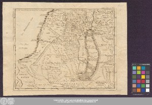
http://dx.doi.org/10.25673/39794| Title: | Der südliche Theil von Palaestina |
| Part: | II. Blatt |
| Publisher / Printer: | Hoffmann, G. C. B. |
| Other: | Sysang, Johanna Dorothea |
| Published: | [Leipzig] / [Cleve] : [G.C.B. Hoffmann] ; Kleve, [1775] |
| Publication place: | Kleve |
| Scale: | Circa 1:620 000 |
| Coordinates: | E 32°20'-E 34°40'/N 33°40'-N 32°10' |
| Extent: | 1 Karte; 27 x 33 cm Kupferstich |
| Annotations: | Koordinaten der Vorlage mit Nullmeridian Ferro: E 050 00-E 052 20/N 033 40-N 032 10 Mit Bergzeichnung Oben rechts: "II. Th. IV. B. am Ende" Erschienen in: Bachiene, Willem Albert: Historische und geographische Beschreibung von Palästina, nach seinem ehemaligen und gegenwärtigen Zustande. - Kleve ; Leipzig : Hoffmann, 1775 ; II. Teil, IV. Band ; XI. Charte, II. Blatt Altkarte |
| Language: | German |
| Online Edition: | Halle (Saale) : Universitäts- und Landesbibliothek Sachsen-Anhalt, 2021 |
| Original Publication: | Universitäts- und Landesbibliothek Sachsen-Anhalt, Altkt B II 6 [1] 14 |
| URN: | urn:nbn:de:gbv:3:3-1192015415-334083559-19 |
| URI: | https://opendata.uni-halle.de//handle/1981185920/41749 http://dx.doi.org/10.25673/39794 |
| Open Access: |  Open access publication Open access publication |
| License: |  Creative Commons Attribution 4.0") (CC BY 4.0) Creative Commons Attribution 4.0 (CC BY 4.0) Creative Commons Attribution 4.0 |
| Sponsor/Funder: | Die Digitalisierung wurde durch die Deutsche Digitale Bibliothek im Rahmen des von der Beauftragten der Bundesregierung für Kultur und Medien (BKM) geförderten Programms NEUSTART KULTUR ermöglicht. |
| Appears in Collections: | Karten und Atlanten |
Ressources:
 |
|