Please use this identifier to cite or link to this item:
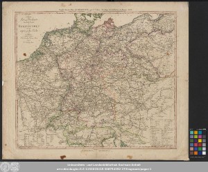
http://dx.doi.org/10.25673/101484| Title: | Neueste Post- und Reisekarte durch die Staaten des Rheinbundes und die angränzenden Länder / von I. T. Ahrens. Joh. Wilh. Kneusel Sculp. |
| Author: | Homannsche Erben |
| Other: | Ahrens, Johann Thomas Kneusel, Johann Wilhelm |
| Published: | Nürnberg : Homanns Erben, 1812 |
| Scale: | [ca. 1:2 300 000] |
| Coordinates: | E 2°45'-E 19°00'/N 55°00'-N 45°00' |
| Extent: | 1 Kt.; 57 x 49 cm Kupferst. |
| Annotations: | Nullmeridian: Ferro. - Maßstab in graph. Form (Geographische Meilen, Französische Lieues) Titel mit Privileg links oben. - Erklärungen rechts unten. - Aufzählung der Rheinischen Bundesstaaten links unten. - Stecher rechts unten im Kartenrahmen. - Maßstab Mitte unten unter Kartenrahmen. - Paralleltitel als Kopftitel Mit Entfernungsangaben Altkarte |
| Language: | German |
| Subjects: | Mitteleuropa Deutschland Post Fahrpost |
| Online Edition: | Halle (Saale) : Universitäts- und Landesbibliothek Sachsen-Anhalt, 2023 |
| Original Publication: | Universitäts- und Landesbibliothek Sachsen-Anhalt, Altkt D I 4 [2] 3 |
| URN: | urn:nbn:de:gbv:3:3-1192015415-308754352-17 |
| URI: | https://opendata.uni-halle.de//handle/1981185920/103442 http://dx.doi.org/10.25673/101484 |
| Open Access: |  Open access publication Open access publication |
| License: |  Creative Commons Attribution 4.0") (CC BY 4.0) Creative Commons Attribution 4.0 (CC BY 4.0) Creative Commons Attribution 4.0 |
| Appears in Collections: | Karten und Atlanten |
Ressources:
 |
|