Please use this identifier to cite or link to this item:
http://dx.doi.org/10.25673/101488Full metadata record
| DC Field | Value | Language |
|---|---|---|
| dc.contributor.other | Maximilian Frommann | - |
| dc.date.accessioned | 2023-03-23T06:00:11Z | - |
| dc.date.available | 2023-03-23T06:00:11Z | - |
| dc.date.issued | 1850 | - |
| dc.identifier.other | eki: GBV:104571691X | - |
| dc.identifier.uri | https://opendata.uni-halle.de//handle/1981185920/103446 | - |
| dc.identifier.uri | http://dx.doi.org/10.25673/101488 | - |
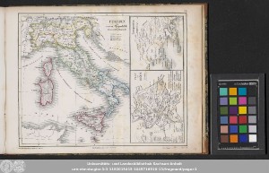
| dc.format.extent | 3 Karten auf 1 Blatt; 21 x 17 cm (links), 9 x 12 cm (rechts unten), 9 x 9 cm (rechts oben), auf Blatt 24 x 31 cm | - |
| dc.format.extent | Lithografie | - |
| dc.language.iso | ger | - |
| dc.publisher | bei Karl Winter | - |
| dc.rights.uri | https://creativecommons.org/licenses/by/4.0/ | - |
| dc.subject.ddc | 090 | - |
| dc.title | Italien als roem. Republik in ihrem vollen Bestande | - |
| dc.title.alternative | Plan von Rom | - |
| dc.title.alternative | Campania | - |
| dc.type | Map | - |
| dc.identifier.urn | urn:nbn:de:gbv:3:3-1192015415-104571691X-13 | - |
| dc.identifier.shelfmark | Altkt P II [1] 11 (4) | - |
| local.openaccess | true | - |
| dc.identifier.ppn | 104571691X | - |
| local.mets.uri | https://opendata.uni-halle.de/retrieve/69e74ca7-37b6-494e-af60-877a4cd6e13e/mets.xml | - |
| local.holding | Universitäts- und Landesbibliothek Sachsen-Anhalt | - |
| local.holding.displayform | Universitäts- und Landesbibliothek Sachsen-Anhalt, Altkt P II [1] 11 (4) | - |
| dc.date.digitization | 2023 | - |
| dc.description.note | Bergstriche | - |
| dc.description.note | Erschienen in: Dittmar, Heinrich: Historischer Atlas. - Heidelberg : Winter, [circa 1850] ; Erste Abtheilung, Tafel VIb | - |
| dc.description.note | Karte | - |
| cbs.contenttype.code | cri | - |
| cbs.contenttype.text | kartografisches Bild | - |
| cbs.digitization.displayform | Halle (Saale) : Universitäts- und Landesbibliothek Sachsen-Anhalt, 2023 | - |
| cbs.publication.displayform | Heidelberg : bei Karl Winter, [circa 1850] | - |
| cbs.picatype | Aa | - |
| local.map.scale | Unterschiedliche Maßstäbe | - |
| dc.contributor.contributor | Dittmar, Heinrich | - |
| Appears in Collections: | Karten und Atlanten | |
Ressources:
 |
|