Please use this identifier to cite or link to this item:
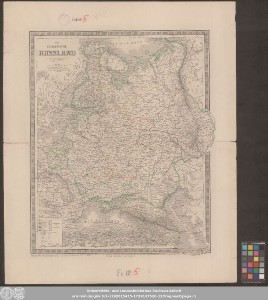
http://dx.doi.org/10.25673/101489| Title: | Das Europäische Russland |
| Publisher / Printer: | Geographisches Institut zu Weimar |
| Published: | Weimar : Geographisches Institut, 1857 |
| Scale: | 1:6 588 000 |
| Coordinates: | E 7°30'00"-E 70°00'00"/N 71°30'00"-N 36°30'00" |
| Edition: | Revidirt von C. Gräf 1857 |
| Extent: | 1 Karte; 56 x 46 cm Stahlstich |
| Annotations: | Nullmeridian: Paris Mit Randüberzeichnung Bergstriche Enthält 1 Nebenkarte von St. Petersburg und Umgebung Karte |
| Note: | Koloriert |
| Language: | German |
| Online Edition: | Halle (Saale) : Universitäts- und Landesbibliothek Sachsen-Anhalt, 2023 |
| Original Publication: | Universitäts- und Landesbibliothek Sachsen-Anhalt, Altkt B II 10 [7] 3 |
| URN: | urn:nbn:de:gbv:3:3-1192015415-1729137520-12 |
| URI: | https://opendata.uni-halle.de//handle/1981185920/103447 http://dx.doi.org/10.25673/101489 |
| Open Access: |  Open access publication Open access publication |
| License: |  Creative Commons Attribution 4.0") (CC BY 4.0) Creative Commons Attribution 4.0 (CC BY 4.0) Creative Commons Attribution 4.0 |
| Appears in Collections: | Karten und Atlanten |
Ressources:
 |
|