Bitte benutzen Sie diese Kennung, um auf die Ressource zu verweisen:
http://dx.doi.org/10.25673/119423Langanzeige der Metadaten
| DC Element | Wert | Sprache |
|---|---|---|
| dc.date.accessioned | 2025-07-12T05:00:36Z | - |
| dc.date.available | 2025-07-12T05:00:36Z | - |
| dc.date.issued | 1890 | - |
| dc.identifier.other | eki: GBV:240248120 | - |
| dc.identifier.uri | https://opendata.uni-halle.de//handle/1981185920/121381 | - |
| dc.identifier.uri | http://dx.doi.org/10.25673/119423 | - |
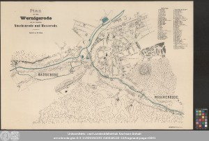
| dc.format.extent | 1 Karte; 59 x 91 cm, Blatt 67 x 100 cm | - |
| dc.format.extent | Farblithografie | - |
| dc.language.iso | ger | - |
| dc.publisher | autographischer Druck von Th. Schäfer | - |
| dc.rights.uri | https://creativecommons.org/licenses/by/4.0/ | - |
| dc.subject | Wernigerode | - |
| dc.subject | Stadtplan | - |
| dc.subject.ddc | 090 | - |
| dc.title | Plan der Stadt Wernigerode mit den Ortschaften Nöschenrode und Hasserode / bearbeitet von H. Gier | - |
| dc.type | Map | - |
| dc.identifier.urn | urn:nbn:de:gbv:3:3-11920154153-240248120-12 | - |
| dc.identifier.shelfmark | Altkt K II 3 [1] 5 | - |
| local.openaccess | true | - |
| dc.identifier.ppn | 240248120 | - |
| local.mets.uri | https://opendata.uni-halle.de/retrieve/ade12674-009a-480d-b8aa-dbd4ee62a8e1/mets.xml | - |
| local.holding | Universitäts- und Landesbibliothek Sachsen-Anhalt | - |
| local.holding.displayform | Universitäts- und Landesbibliothek Sachsen-Anhalt, Altkt K II 3 [1] 5 | - |
| dc.contributor.cartographer | Gier, H. | - |
| dc.contributor.publisher | Schäfer, Th. | - |
| dc.date.digitization | 2025 | - |
| dc.description.note | Ohne Kartennetz und Randgraduierung | - |
| dc.description.note | Titel oben links. - Erläuterungen oben rechts. - Drucker unten rechts | - |
| dc.description.note | Inselkarte | - |
| dc.description.note | Karte | - |
| cbs.contenttype.code | cri | - |
| cbs.contenttype.text | kartografisches Bild | - |
| cbs.digitization.displayform | Halle (Saale) : Universitäts- und Landesbibliothek Sachsen-Anhalt, 2025 | - |
| cbs.publication.displayform | Hannover : autographischer Druck von Th. Schäfer, [circa 1890] | - |
| cbs.picatype | Aa | - |
| local.map.scale | circa 1:4 600 | - |
| local.map.scale_sort | 1:4600 | - |
| local.map.coordinates | E 010 45 35-E 010 48 40/N 051 50 33-N 051 49 15 | - |
| Enthalten in den Sammlungen: | Karten und Atlanten | |
Ressourcen:
 |
|