Please use this identifier to cite or link to this item:
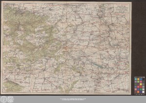
http://dx.doi.org/10.25673/38835| Title: | Pharus-Wanderkarte des Mansfelder See- u. Gebirgskreises und des Kreises Eisleben / Urheber Dr. Cornelius Löwe |
| Publisher / Printer: | Probst, Walter Pharus-Verlag |
| Published: | Berlin / Eisleben : Lith., Druck, Verlag u. Eigentum Pharus-Verlag G.m.b.H. ; Iso-Verlag Walter Probst, [circa 1925] |
| Scale: | 1:80 000 |
| Extent: | 1 Karte; 52 x 74 cm farbig |
| Annotations: | Titel-, Maßstabs- und Erklärungskartusche oben rechts Ohne Randgraduierung Mit Schummerung Karte |
| Language: | German |
| Subjects: | Landkreis Mansfelder Land Mansfelder Seen Eisleben Wanderkarte |
| Online Edition: | Halle (Saale) : Universitäts- und Landesbibliothek Sachsen-Anhalt, 2021 |
| Original Publication: | Universitäts- und Landesbibliothek Sachsen-Anhalt, Altkt D II 7 [2] 21 |
| URN: | urn:nbn:de:gbv:3:3-1192015415-251169065-11 |
| URI: | https://opendata.uni-halle.de//handle/1981185920/39082 http://dx.doi.org/10.25673/38835 |
| Open Access: |  Open access publication Open access publication |
| License: |  Creative Commons Attribution 4.0") (CC BY 4.0) Creative Commons Attribution 4.0 (CC BY 4.0) Creative Commons Attribution 4.0 |
| Sponsor/Funder: | Die Digitalisierung wurde durch die Deutsche Digitale Bibliothek im Rahmen des von der Beauftragten der Bundesregierung für Kultur und Medien (BKM) geförderten Programms NEUSTART KULTUR ermöglicht. |
| Appears in Collections: | Karten und Atlanten |
Ressources:
 |
|