Bitte benutzen Sie diese Kennung, um auf die Ressource zu verweisen:
http://dx.doi.org/10.25673/39103Langanzeige der Metadaten
| DC Element | Wert | Sprache |
|---|---|---|
| dc.contributor.other | Nicolson, William | - |
| dc.date.accessioned | 2021-11-04T11:08:51Z | - |
| dc.date.available | 2021-11-04T11:08:51Z | - |
| dc.date.issued | 1681 | - |
| dc.identifier.uri | https://opendata.uni-halle.de//handle/1981185920/39750 | - |
| dc.identifier.uri | http://dx.doi.org/10.25673/39103 | - |
| dc.description.sponsorship | Die Digitalisierung wurde durch die Deutsche Digitale Bibliothek im Rahmen des von der Beauftragten der Bundesregierung für Kultur und Medien (BKM) geförderten Programms NEUSTART KULTUR ermöglicht. | - |
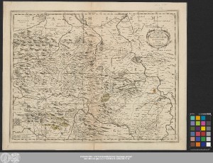
| dc.format.extent | 1 Karte; 36 x 46 cm | - |
| dc.format.extent | Kupferstich | - |
| dc.language.iso | lat | - |
| dc.publisher | Apud Janssonio-Waesbergios, Mosem Pitt et Staphanum Swart | - |
| dc.rights.uri | https://creativecommons.org/licenses/by/4.0/ | - |
| dc.subject | Grafschaft Mansfeld | - |
| dc.subject.ddc | 090 | - |
| dc.subject.other | BK:74.20 | - |
| dc.title | Comitatvs Mansfeldiæ Descriptio / Auctore Tilemanno Stella Sig. | - |
| dc.type | Map | - |
| dc.identifier.urn | urn:nbn:de:gbv:3:3-1192015415-236520075-12 | - |
| dc.identifier.shelfmark | Altkt D II 7 [1] 3 | - |
| local.openaccess | true | - |
| dc.identifier.ppn | 236520075 | - |
| local.mets.uri | https://opendata.uni-halle.de/retrieve/5c8e6b21-0959-4396-8a27-5c6c9539e6a4/mets.xml | - |
| local.holding | Universitäts- und Landesbibliothek Sachsen-Anhalt | - |
| local.holding.displayform | Universitäts- und Landesbibliothek Sachsen-Anhalt, Altkt D II 7 [1] 3 | - |
| dc.contributor.cartographer | Stella, Tilemann | - |
| dc.contributor.publisher | Waesberghe, Joannes Janssonius, van | - |
| dc.contributor.publisher | Pitt, Moses | - |
| dc.contributor.publisher | Swart, Stephan | - |
| dc.contributor.publisher | Janssonio-Waesbergii | - |
| dc.date.digitization | 2021 | - |
| dc.description.note | Maßstab in grafischer Form (Miliaria Germanica) | - |
| dc.description.note | Titelkartusche oben rechts. - Verleger unten links. - Maßstab unten Mitte | - |
| dc.description.note | Mit Bergzeichnung | - |
| dc.description.note | Oben rechts: "XX" | - |
| dc.description.note | Erschienen in: Nicolson, William: The English atlas. - Oxford : Pitt, 1681 ; vol. 2 : Containing the description of part of the empire of Germany ... ; Karte XX | - |
| dc.description.note | Altkarte | - |
| cbs.contenttype.code | cri | - |
| cbs.contenttype.text | kartografisches Bild | - |
| cbs.digitization.displayform | Halle (Saale) : Universitäts- und Landesbibliothek Sachsen-Anhalt, 2021 | - |
| cbs.publication.displayform | [Oxford] : Apud Janssonio-Waesbergios, Mosem Pitt et Staphanum Swart, [1681] | - |
| cbs.picatype | Aa | - |
| dc.title.uniform | Comitatus Mansfeldiae descriptio | - |
| local.map.scale | Circa 1:160 000 | - |
| local.map.scale_sort | 1:160000 | - |
| local.map.coordinates | E 009 55-E 012 03/N 051 49-N 051 14 | - |
| Enthalten in den Sammlungen: | Karten und Atlanten | |
Ressourcen:
 |
|