Please use this identifier to cite or link to this item:
http://dx.doi.org/10.25673/39107Full metadata record
| DC Field | Value | Language |
|---|---|---|
| dc.date.accessioned | 2021-11-04T11:11:26Z | - |
| dc.date.available | 2021-11-04T11:11:26Z | - |
| dc.date.issued | 1757 | - |
| dc.identifier.uri | https://opendata.uni-halle.de//handle/1981185920/39754 | - |
| dc.identifier.uri | http://dx.doi.org/10.25673/39107 | - |
| dc.description.sponsorship | Die Digitalisierung wurde durch die Deutsche Digitale Bibliothek im Rahmen des von der Beauftragten der Bundesregierung für Kultur und Medien (BKM) geförderten Programms NEUSTART KULTUR ermöglicht. | - |
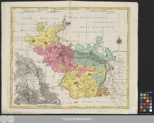
| dc.format.extent | 1 Karte; 47 x 55 cm | - |
| dc.format.extent | Kupferstich | - |
| dc.language.iso | lat | - |
| dc.language.iso | ger | - |
| dc.publisher | Anjezo im Verlag beÿ Tobias Conrad Lotter, Geogr. | - |
| dc.rights.uri | https://creativecommons.org/licenses/by/4.0/ | - |
| dc.subject | Hochstift Merseburg | - |
| dc.subject.ddc | 090 | - |
| dc.title | Delineatio Geographica Ditionis Martisburgensis hodie regiis et electoralibus auspiciis florentis / edita à Matth. Seutt. S.C.M. Geogr. Aug. Vindel. ; Tob. Conr. Lotter sculps. | - |
| dc.type | Map | - |
| dc.identifier.urn | urn:nbn:de:gbv:3:3-1192015415-236879200-18 | - |
| dc.identifier.shelfmark | Altkt D II 7 [3] 9 | - |
| local.openaccess | true | - |
| dc.identifier.ppn | 236879200 | - |
| local.comment.extern | Koloriert | - |
| local.mets.uri | https://opendata.uni-halle.de/retrieve/8ec865c5-e31c-4d1a-94b1-8ae563bc5d19/mets.xml | - |
| local.holding | Universitäts- und Landesbibliothek Sachsen-Anhalt | - |
| local.holding.displayform | Universitäts- und Landesbibliothek Sachsen-Anhalt, Altkt D II 7 [3] 9 | - |
| dc.contributor.cartographer | Seutter, Matthäus | - |
| dc.contributor.publisher | Lotter, Tobias Conrad | - |
| dc.date.digitization | 2021 | - |
| dc.description.note | "Cum Privilegio S. Reg. Maj. Poloniæ Elect. Sax." | - |
| dc.description.note | Maßstab in grafischer Form (Meilen, Poleicey Meile) | - |
| dc.description.note | Titelkartusche mit allegorischer Darstellung unten links. - Maßstab oben Mitte links und Mitte rechts. - Verleger unter Titelkartusche. - Stecher unten rechts auf Kartenrand | - |
| dc.description.note | Mit Windrose und Bergzeichnung | - |
| dc.description.note | Altkarte | - |
| cbs.contenttype.code | cri | - |
| cbs.contenttype.text | kartografisches Bild | - |
| cbs.digitization.displayform | Halle (Saale) : Universitäts- und Landesbibliothek Sachsen-Anhalt, 2021 | - |
| cbs.publication.displayform | In Augsburg : Anjezo im Verlag beÿ Tobias Conrad Lotter, Geogr., [zwischen 1757 und 1777] | - |
| cbs.picatype | Aa | - |
| local.map.scale | Circa 1:80 000 | - |
| local.map.scale_sort | 1:80000 | - |
| Appears in Collections: | Karten und Atlanten | |
Ressources:
 |
|