Bitte benutzen Sie diese Kennung, um auf die Ressource zu verweisen:
http://dx.doi.org/10.25673/39165Langanzeige der Metadaten
| DC Element | Wert | Sprache |
|---|---|---|
| dc.date.accessioned | 2021-11-04T15:15:18Z | - |
| dc.date.available | 2021-11-04T15:15:18Z | - |
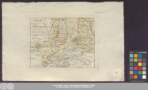
| dc.date.issued | 1796 | - |
| dc.identifier.uri | https://opendata.uni-halle.de//handle/1981185920/40112 | - |
| dc.identifier.uri | http://dx.doi.org/10.25673/39165 | - |
| dc.description.sponsorship | Die Digitalisierung wurde durch die Deutsche Digitale Bibliothek im Rahmen des von der Beauftragten der Bundesregierung für Kultur und Medien (BKM) geförderten Programms NEUSTART KULTUR ermöglicht. | - |
| dc.format.extent | 1 Karte; 18 x 23 cm | - |
| dc.format.extent | Kupferstich | - |
| dc.language.iso | ger | - |
| dc.publisher | [Landes-Industrie-Comptoir] | - |
| dc.rights.uri | https://creativecommons.org/licenses/by/4.0/ | - |
| dc.subject | Rhön | - |
| dc.subject.ddc | 090 | - |
| dc.title | Charte von dem Rhoengebirge mit den anliegenden Orten / aufgenommen von Georg Schrenk ; Gezeichnet v. F.L. Güssefeld | - |
| dc.type | Map | - |
| dc.identifier.urn | urn:nbn:de:gbv:3:3-1192015415-245934944-12 | - |
| dc.identifier.shelfmark | Altkt B III 8 [3] 1a | - |
| local.openaccess | true | - |
| dc.identifier.ppn | 245934944 | - |
| local.mets.uri | https://opendata.uni-halle.de/retrieve/4e49045e-6692-499f-9fa9-18643f06883e/mets.xml | - |
| local.holding | Universitäts- und Landesbibliothek Sachsen-Anhalt | - |
| local.holding.displayform | Universitäts- und Landesbibliothek Sachsen-Anhalt, Altkt B III 8 [3] 1a | - |
| dc.contributor.cartographer | Güssefeld, Franz L. | - |
| dc.contributor.cartographer | Schrenk, Georg | - |
| dc.contributor.publisher | Landes-Industrie-Comptoir zu Weimar | - |
| dc.date.digitization | 2021 | - |
| dc.description.note | Maßstab in grafischer Form (Meile) | - |
| dc.description.note | Titel und Maßstab oben links | - |
| dc.description.note | Mit Bergstrichen | - |
| dc.description.note | Ohne Kartennetz und Randgraduierung | - |
| dc.description.note | Altkarte | - |
| cbs.contenttype.code | cri | - |
| cbs.contenttype.text | kartografisches Bild | - |
| cbs.digitization.displayform | Halle (Saale) : Universitäts- und Landesbibliothek Sachsen-Anhalt, 2021 | - |
| cbs.publication.displayform | [Weimar] : [Landes-Industrie-Comptoir], [1796] | - |
| cbs.picatype | Aa | - |
| local.map.scale | Circa 1:140 000 | - |
| local.map.scale_sort | 1:140000 | - |
| Enthalten in den Sammlungen: | Karten und Atlanten | |
Ressourcen:
 |
|