Bitte benutzen Sie diese Kennung, um auf die Ressource zu verweisen:
http://dx.doi.org/10.25673/39296Langanzeige der Metadaten
| DC Element | Wert | Sprache |
|---|---|---|
| dc.date.accessioned | 2021-11-08T15:41:52Z | - |
| dc.date.available | 2021-11-08T15:41:52Z | - |
| dc.date.issued | 1807 | - |
| dc.identifier.uri | https://opendata.uni-halle.de//handle/1981185920/41250 | - |
| dc.identifier.uri | http://dx.doi.org/10.25673/39296 | - |
| dc.description.sponsorship | Die Digitalisierung wurde durch die Deutsche Digitale Bibliothek im Rahmen des von der Beauftragten der Bundesregierung für Kultur und Medien (BKM) geförderten Programms NEUSTART KULTUR ermöglicht. | - |
| dc.format.extent | 1 Karte; 102 x 81 cm | - |
| dc.format.extent | Kupferstich | - |
| dc.language.iso | ger | - |
| dc.publisher | Im Kunst und Industrie Comptoir | - |
| dc.rights.uri | https://creativecommons.org/licenses/by/4.0/ | - |
| dc.subject.ddc | 090 | - |
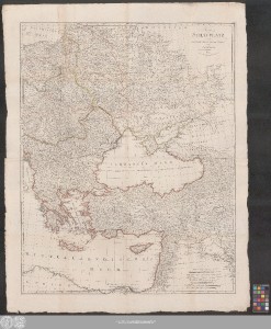
| dc.title | Kriegs Schauplatz zwischen Preussen Russland, Der Türkey und Frankreich | - |
| dc.type | Map | - |
| dc.identifier.urn | urn:nbn:de:gbv:3:3-1192015415-600735206-13 | - |
| dc.identifier.shelfmark | Altkt K II 5 [1] 13 | - |
| local.openaccess | true | - |
| dc.identifier.ppn | 600735206 | - |
| local.comment.extern | Koloriert | - |
| local.mets.uri | https://opendata.uni-halle.de/retrieve/b91330c2-0cb6-4c27-83ce-71a6bcb22f96/mets.xml | - |
| local.holding | Universitäts- und Landesbibliothek Sachsen-Anhalt | - |
| local.holding.displayform | Universitäts- und Landesbibliothek Sachsen-Anhalt, Altkt K II 5 [1] 13 | - |
| dc.contributor.cartographer | Kunst- und Industrie-Comptoir | - |
| dc.date.digitization | 2021 | - |
| dc.description.note | Maßstab in grafischer Form (Geographische Meilen, Französische Meilen, Gemeine polnische Meilen, Gemeine ungarische Meilen ...) | - |
| dc.description.note | Titelkartusche oben rechts | - |
| dc.description.note | Mit Bergzeichnung | - |
| dc.description.note | Randüberzeichnung | - |
| dc.description.note | Oben rechts: "N. 9" | - |
| dc.description.note | Auf 2 Blättern gedruckt | - |
| dc.description.note | Altkarte | - |
| cbs.contenttype.code | cri | - |
| cbs.contenttype.text | kartografisches Bild | - |
| cbs.digitization.displayform | Halle (Saale) : Universitäts- und Landesbibliothek Sachsen-Anhalt, 2021 | - |
| cbs.publication.displayform | Wien : Im Kunst und Industrie Comptoir, 1807 | - |
| cbs.picatype | Aa | - |
| local.map.scale | Circa 1:2 800 000 | - |
| local.map.scale_sort | 1:2800000 | - |
| Enthalten in den Sammlungen: | Karten und Atlanten | |
Ressourcen:
 |
|