Bitte benutzen Sie diese Kennung, um auf die Ressource zu verweisen:
http://dx.doi.org/10.25673/39388Langanzeige der Metadaten
| DC Element | Wert | Sprache |
|---|---|---|
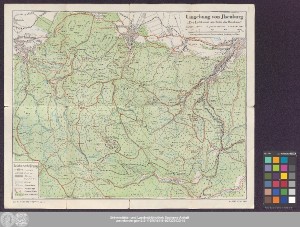
| dc.contributor.other | Ilsenburg, Harz | - |
| dc.date.accessioned | 2021-11-10T15:18:15Z | - |
| dc.date.available | 2021-11-10T15:18:15Z | - |
| dc.date.issued | 1940 | - |
| dc.identifier.uri | https://opendata.uni-halle.de//handle/1981185920/41344 | - |
| dc.identifier.uri | http://dx.doi.org/10.25673/39388 | - |
| dc.description.sponsorship | Die Digitalisierung wurde durch die Deutsche Digitale Bibliothek im Rahmen des von der Beauftragten der Bundesregierung für Kultur und Medien (BKM) geförderten Programms NEUSTART KULTUR ermöglicht. | - |
| dc.format.extent | 1 Karte; 35 x 44 cm, gefaltet 19 x 12 cm | - |
| dc.format.extent | farbig | - |
| dc.language.iso | ger | - |
| dc.publisher | MDV | - |
| dc.rights.uri | https://creativecommons.org/licenses/by/4.0/ | - |
| dc.subject.ddc | 090 | - |
| dc.title | Umgebung von Ilsenburg : "Der Luftkurort am Fuße des Brockens" / herausgegeben von der Kurverwaltung Ilsenburg am Harz | - |
| dc.type | Map | - |
| dc.identifier.urn | urn:nbn:de:gbv:3:3-1192015415-502332433-16 | - |
| dc.identifier.shelfmark | Altkt T I [3] 8 / 6 | - |
| local.openaccess | true | - |
| dc.identifier.ppn | 502332433 | - |
| local.mets.uri | https://opendata.uni-halle.de/retrieve/556a8323-1098-426a-9025-061fffcfa771/mets.xml | - |
| local.holding | Universitäts- und Landesbibliothek Sachsen-Anhalt | - |
| local.holding.displayform | Universitäts- und Landesbibliothek Sachsen-Anhalt, Altkt T I [3] 8 / 6 | - |
| dc.date.digitization | 2021 | - |
| dc.description.note | Mit Nordpfeil | - |
| dc.description.note | Ohne Kartennetz und Randgraduierung | - |
| dc.description.note | Karte | - |
| cbs.contenttype.code | cri | - |
| cbs.contenttype.text | kartografisches Bild | - |
| cbs.digitization.displayform | Halle (Saale) : Universitäts- und Landesbibliothek Sachsen-Anhalt, 2021 | - |
| cbs.publication.displayform | Wernigerode : MDV, [circa 1940?] | - |
| cbs.picatype | Aa | - |
| local.map.scale | 1:40 000 | - |
| local.map.scale_sort | 1:40000 | - |
| Enthalten in den Sammlungen: | Karten und Atlanten | |
Ressourcen:
 |
|