Bitte benutzen Sie diese Kennung, um auf die Ressource zu verweisen:
http://dx.doi.org/10.25673/39401Langanzeige der Metadaten
| DC Element | Wert | Sprache |
|---|---|---|
| dc.date.accessioned | 2021-11-11T11:03:49Z | - |
| dc.date.available | 2021-11-11T11:03:49Z | - |
| dc.date.issued | 1900 | - |
| dc.identifier.uri | https://opendata.uni-halle.de//handle/1981185920/41357 | - |
| dc.identifier.uri | http://dx.doi.org/10.25673/39401 | - |
| dc.description.sponsorship | Die Digitalisierung wurde durch die Deutsche Digitale Bibliothek im Rahmen des von der Beauftragten der Bundesregierung für Kultur und Medien (BKM) geförderten Programms NEUSTART KULTUR ermöglicht. | - |
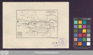
| dc.format.extent | 1 Karte; 9 x 14 cm | - |
| dc.format.extent | Lithografie | - |
| dc.language.iso | ger | - |
| dc.publisher | Geograph. Anstalt von Wagner & Debes | - |
| dc.rights.uri | https://creativecommons.org/licenses/by/4.0/ | - |
| dc.subject.ddc | 090 | - |
| dc.title | Damascus (Dimeschk Esch-Schâm) / nach J.L. Porter | - |
| dc.type | Map | - |
| dc.identifier.urn | urn:nbn:de:gbv:3:3-1192015415-1755363915-13 | - |
| dc.identifier.shelfmark | 21 C 120 | - |
| local.openaccess | true | - |
| dc.identifier.ppn | 1755363915 | - |
| local.mets.uri | https://opendata.uni-halle.de/retrieve/634fa649-f10f-469d-a54f-eb58cc14822b/mets.xml | - |
| local.holding | Universitäts- und Landesbibliothek Sachsen-Anhalt | - |
| local.holding.displayform | Universitäts- und Landesbibliothek Sachsen-Anhalt, 21 C 120 | - |
| dc.contributor.cartographer | Porter, Josias Leslie | - |
| dc.contributor.publisher | H. Wagner & E. Debes | - |
| dc.date.digitization | 2021 | - |
| dc.description.note | Maßstab in grafischer Form (Meter) | - |
| dc.description.note | Ohne Kartennetz und Randgraduierung | - |
| dc.description.note | Stadtplan | - |
| cbs.contenttype.code | cri | - |
| cbs.contenttype.text | kartografisches Bild | - |
| cbs.digitization.displayform | Halle (Saale) : Universitäts- und Landesbibliothek Sachsen-Anhalt, 2021 | - |
| cbs.publication.displayform | Leipzig : Geograph. Anstalt von Wagner & Debes, [circa 1900] | - |
| cbs.picatype | Aa | - |
| local.map.scale | 1:22 000 | - |
| local.map.scale_sort | 1:22000 | - |
| local.map.coordinates | E 036 17 28/N 033 30 36 | - |
| Enthalten in den Sammlungen: | Karten und Atlanten | |
Ressourcen:
 |
|