Please use this identifier to cite or link to this item:
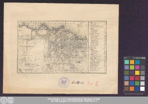
http://dx.doi.org/10.25673/39402| Title: | Bêrût (Berytus) / nach einer Originalaufnahme von Jul. Loytved und der Karte von Commr. A.L. Mansell |
| Publisher / Printer: | H. Wagner & E. Debes |
| Published: | Leipzig : Geograph. Anstalt von Wagner & Debes, [circa 1900] |
| Scale: | 1:20 000 |
| Coordinates: | E 35°29'39"/N 33°53'20" |
| Extent: | 1 Karte; 14 x 20 cm, auf Blatt 26 x 33 cm Lithografie |
| Annotations: | Maßstab in grafischer Form (Meter, Schritt) Mit Suchnetz Bergstriche Stadtplan |
| Language: | German |
| Online Edition: | Halle (Saale) : Universitäts- und Landesbibliothek Sachsen-Anhalt, 2021 |
| Original Publication: | Universitäts- und Landesbibliothek Sachsen-Anhalt, 21 C 126 |
| URN: | urn:nbn:de:gbv:3:3-1192015415-1755370121-11 |
| URI: | https://opendata.uni-halle.de//handle/1981185920/41358 http://dx.doi.org/10.25673/39402 |
| Open Access: |  Open access publication Open access publication |
| License: |  Creative Commons Attribution 4.0") (CC BY 4.0) Creative Commons Attribution 4.0 (CC BY 4.0) Creative Commons Attribution 4.0 |
| Sponsor/Funder: | Die Digitalisierung wurde durch die Deutsche Digitale Bibliothek im Rahmen des von der Beauftragten der Bundesregierung für Kultur und Medien (BKM) geförderten Programms NEUSTART KULTUR ermöglicht. |
| Appears in Collections: | Karten und Atlanten |
Ressources:
 |
|