Bitte benutzen Sie diese Kennung, um auf die Ressource zu verweisen:
http://dx.doi.org/10.25673/39445Langanzeige der Metadaten
| DC Element | Wert | Sprache |
|---|---|---|
| dc.contributor.other | Powell, G. S. | - |
| dc.contributor.other | Potter, J. D. | - |
| dc.contributor.other | Davies & Company | - |
| dc.date.accessioned | 2021-11-12T11:01:01Z | - |
| dc.date.available | 2021-11-12T11:01:01Z | - |
| dc.date.issued | 1883 | - |
| dc.identifier.uri | https://opendata.uni-halle.de//handle/1981185920/41401 | - |
| dc.identifier.uri | http://dx.doi.org/10.25673/39445 | - |
| dc.description.sponsorship | Die Digitalisierung wurde durch die Deutsche Digitale Bibliothek im Rahmen des von der Beauftragten der Bundesregierung für Kultur und Medien (BKM) geförderten Programms NEUSTART KULTUR ermöglicht. | - |
| dc.format.extent | 1 Karte; 100 x 63 cm | - |
| dc.language.iso | eng | - |
| dc.publisher | published at the Admiralty under the superintendence of Rear Admiral G.H. Richards, C.B.F.R.S., hydrographer | - |
| dc.publisher | sold by J.D. Potter, Agent for the sale of the Admiralty Charts | - |
| dc.rights.uri | https://creativecommons.org/licenses/by/4.0/ | - |
| dc.subject.ddc | 090 | - |
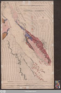
| dc.title | Gulf of Suez : Red Sea / surveyed by Captain G.S. Nares, R.N. ; drawn by R.C. Carrington, Hyd. Off. under the direction of Captain R. Hoskyn R.N. Superintendent of Charts ; engraved by Davies & Company, views engraved by G.S. Powell | - |
| dc.type | Map | - |
| dc.identifier.urn | urn:nbn:de:gbv:3:3-1192015415-1737598736-16 | - |
| dc.identifier.shelfmark | Altkt K II 5 [3] 1 | - |
| local.openaccess | true | - |
| dc.identifier.ppn | 1737598736 | - |
| local.comment.extern | Koloriert | - |
| local.mets.uri | https://opendata.uni-halle.de/retrieve/5ea970c2-a546-48d4-8252-28bf1d94b9aa/mets.xml | - |
| local.holding | Universitäts- und Landesbibliothek Sachsen-Anhalt | - |
| local.holding.displayform | Universitäts- und Landesbibliothek Sachsen-Anhalt, Altkt K II 5 [3] 1 | - |
| dc.contributor.cartographer | Carrington, Robert Christopher | - |
| dc.contributor.cartographer | Nares, George Strong | - |
| dc.contributor.cartographer | Hoskyn, R. | - |
| dc.contributor.publisher | Richards, G. H. | - |
| dc.date.digitization | 2021 | - |
| dc.description.note | Bergstriche | - |
| dc.description.note | Enthält 6 Ansichten: "Rás Gharib Lighthouse", "Zafarana Lighthouse", "View from Suez Bay looking Sothward", "View of the Western Coast from Zeiti Hills to Zafarana", "View of the Eastern Coast from Rás Jehan to Towilah" ... | - |
| dc.description.note | "Magnetic Variation in 1883" | - |
| dc.description.note | Nummerierung unten rechts: "757" | - |
| dc.description.note | Karte | - |
| cbs.contenttype.code | cri | - |
| cbs.contenttype.text | kartografisches Bild | - |
| cbs.digitization.displayform | Halle (Saale) : Universitäts- und Landesbibliothek Sachsen-Anhalt, 2021 | - |
| cbs.publication.displayform | London / [London] : published at the Admiralty under the superintendence of Rear Admiral G.H. Richards, C.B.F.R.S., hydrographer ; sold by J.D. Potter, Agent for the sale of the Admiralty Charts, [1883?] | - |
| cbs.picatype | Aa | - |
| local.map.scale | Circa 1:320 000 | - |
| local.map.scale_sort | 1:320000 | - |
| local.map.coordinates | E 032 20 00-E 034 27 00/N 030 00 00-N 027 10 00 | - |
| local.publication.edition | Small corrections XII-79 | - |
| Enthalten in den Sammlungen: | Karten und Atlanten | |
Ressourcen:
 |
|