Bitte benutzen Sie diese Kennung, um auf die Ressource zu verweisen:
http://dx.doi.org/10.25673/39948Langanzeige der Metadaten
| DC Element | Wert | Sprache |
|---|---|---|
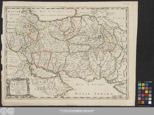
| dc.contributor.other | Somer, Jean | - |
| dc.date.accessioned | 2021-12-06T11:01:49Z | - |
| dc.date.available | 2021-12-06T11:01:49Z | - |
| dc.date.issued | 1658 | - |
| dc.identifier.uri | https://opendata.uni-halle.de//handle/1981185920/41903 | - |
| dc.identifier.uri | http://dx.doi.org/10.25673/39948 | - |
| dc.description.sponsorship | Die Digitalisierung wurde durch die Deutsche Digitale Bibliothek im Rahmen des von der Beauftragten der Bundesregierung für Kultur und Medien (BKM) geförderten Programms NEUSTART KULTUR ermöglicht. | - |
| dc.format.extent | 1 Karte; 38 x 51 cm | - |
| dc.format.extent | Kupferstich | - |
| dc.language.iso | fre | - |
| dc.publisher | Chéz l'Autheur | - |
| dc.rights.uri | https://creativecommons.org/licenses/by/4.0/ | - |
| dc.subject.ddc | 090 | - |
| dc.title | Description De L'Empire Du Sophi Des Perses / tirée en partie de l'Arabe de Nubie, et en partie de plusieurs et diverses Relations Par le Sr. Sanson d'Abbeville Geographe Ordinaire du Roy ; I. Somer Sculp. | - |
| dc.type | Map | - |
| dc.identifier.urn | urn:nbn:de:gbv:3:3-1192015415-1436401941-16 | - |
| dc.identifier.shelfmark | Altkt C III 2 [4] 4 | - |
| local.openaccess | true | - |
| dc.identifier.ppn | 1436401941 | - |
| local.comment.extern | Koloriert | - |
| local.mets.uri | https://opendata.uni-halle.de/retrieve/72b3979d-485a-4ea5-bc4d-9aed0546e77d/mets.xml | - |
| local.holding | Universitäts- und Landesbibliothek Sachsen-Anhalt | - |
| local.holding.displayform | Universitäts- und Landesbibliothek Sachsen-Anhalt, Altkt C III 2 [4] 4 | - |
| dc.contributor.cartographer | Sanson, Nicolas | - |
| dc.contributor.publisher | Mariette, Pierre | - |
| dc.date.digitization | 2021 | - |
| dc.description.note | Titel- und Verlegerkartusche unten links | - |
| dc.description.note | Mit Bergzeichnung | - |
| dc.description.note | Ohne Kartennetz | - |
| dc.description.note | "avec Privuilege du Roy pour vingt Ans" | - |
| dc.description.note | Altkarte | - |
| cbs.contenttype.code | cri | - |
| cbs.contenttype.text | kartografisches Bild | - |
| cbs.digitization.displayform | Halle (Saale) : Universitäts- und Landesbibliothek Sachsen-Anhalt, 2021 | - |
| cbs.publication.displayform | A Paris : Chéz l'Autheur, [circa 1658] | - |
| cbs.picatype | Aa | - |
| local.map.scale | Circa 1:7 400 000 | - |
| local.map.scale_sort | 1:7400000 | - |
| Enthalten in den Sammlungen: | Karten und Atlanten | |
Ressourcen:
 |
|