Please use this identifier to cite or link to this item:
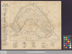
http://dx.doi.org/10.25673/39972| Title: | Plan der Stadt Erfurt |
| Publisher / Printer: | Gerhardt & Schreiber |
| Published: | In Erfurt : Eigenthum von Gerhardt & Schreiber, [circa 1860] |
| Scale: | Circa 1:6 000 |
| Coordinates: | E 11°01'58"/N 50°58'43" |
| Extent: | 1 Karte; 29 x 37 cm, auf Blatt 37 x 45 cm Lithografie |
| Annotations: | Stadtplan |
| Language: | German |
| Subjects: | Erfurt Stadtplan |
| Online Edition: | Halle (Saale) : Universitäts- und Landesbibliothek Sachsen-Anhalt, 2021 |
| Original Publication: | Universitäts- und Landesbibliothek Sachsen-Anhalt, Altkt A III 2 [11] 5 |
| URN: | urn:nbn:de:gbv:3:3-1192015415-243707622-10 |
| URI: | https://opendata.uni-halle.de//handle/1981185920/41926 http://dx.doi.org/10.25673/39972 |
| Open Access: |  Open access publication Open access publication |
| License: |  Creative Commons Attribution 4.0") (CC BY 4.0) Creative Commons Attribution 4.0 (CC BY 4.0) Creative Commons Attribution 4.0 |
| Sponsor/Funder: | Die Digitalisierung wurde durch die Deutsche Digitale Bibliothek im Rahmen des von der Beauftragten der Bundesregierung für Kultur und Medien (BKM) geförderten Programms NEUSTART KULTUR ermöglicht. |
| Appears in Collections: | Karten und Atlanten |
Ressources:
 |
|