Bitte benutzen Sie diese Kennung, um auf die Ressource zu verweisen:
http://dx.doi.org/10.25673/43128Langanzeige der Metadaten
| DC Element | Wert | Sprache |
|---|---|---|
| dc.date.accessioned | 2021-12-16T13:56:08Z | - |
| dc.date.available | 2021-12-16T13:56:08Z | - |
| dc.date.issued | 1915 | - |
| dc.identifier.uri | https://opendata.uni-halle.de//handle/1981185920/45082 | - |
| dc.identifier.uri | http://dx.doi.org/10.25673/43128 | - |
| dc.description.sponsorship | Die Digitalisierung wurde durch die Deutsche Digitale Bibliothek im Rahmen des von der Beauftragten der Bundesregierung für Kultur und Medien (BKM) geförderten Programms NEUSTART KULTUR ermöglicht. | - |
| dc.format.extent | 1 Karte; 43 x 56 cm, auf Blatt 53 x 66 cm, gefaltet 27 x 17 cm | - |
| dc.format.extent | 1 Beiheft (24 Seiten) | - |
| dc.language.iso | eng | - |
| dc.language.iso | ger | - |
| dc.publisher | [W. & A.K. Johnston limited] | - |
| dc.rights.uri | https://creativecommons.org/licenses/by/4.0/ | - |
| dc.subject.ddc | 090 | - |
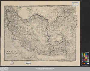
| dc.title | Persia and Afghanistan / engraved, printed and published by W. & A.K. Johnston limited ; vervielfältigt im Auftrage der Kartogr. Abt. des stellv. Generalstabes | - |
| dc.type | Map | - |
| dc.identifier.urn | urn:nbn:de:gbv:3:3-1192015415-865955352-15 | - |
| dc.identifier.shelfmark | 21 C 21 | - |
| local.openaccess | true | - |
| dc.identifier.ppn | 865955352 | - |
| local.comment.extern | Ohne Beiheft | - |
| local.mets.uri | https://opendata.uni-halle.de/retrieve/e83e7274-94c8-4494-a8de-e88f452c4b67/mets.xml | - |
| local.holding | Universitäts- und Landesbibliothek Sachsen-Anhalt | - |
| local.holding.displayform | Universitäts- und Landesbibliothek Sachsen-Anhalt, 21 C 21 | - |
| dc.contributor.cartographer | W. & A. K. Johnston Limited | - |
| dc.contributor.publisher | Deutsches Reich | - |
| dc.date.digitization | 2021 | - |
| dc.description.note | Maßstab in grafischer Form (geographical miles, kilometres, English statute miles) | - |
| dc.description.note | "Keith Johnston's General Atlas" | - |
| dc.description.note | Bergstriche | - |
| dc.description.note | Randüberzeichnung | - |
| dc.description.note | Karte | - |
| cbs.contenttype.code | cri | - |
| cbs.contenttype.text | kartografisches Bild | - |
| cbs.digitization.displayform | Halle (Saale) : Universitäts- und Landesbibliothek Sachsen-Anhalt, 2021 | - |
| cbs.publication.displayform | [London] / [Edinburgh] : [W. & A.K. Johnston limited], 1915 | - |
| cbs.picatype | Aa | - |
| local.map.scale | 1:4 311 000 | - |
| local.map.scale_sort | 1:4311000 | - |
| local.map.coordinates | E 044 10 00-E 072 01 00/N 040 40 00-N 023 41 00 | - |
| Enthalten in den Sammlungen: | Karten und Atlanten | |
Ressourcen:
 |
|