Please use this identifier to cite or link to this item:
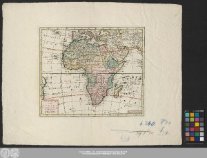
http://dx.doi.org/10.25673/58083| Title: | Nieuwe Kaart Van Africa / na de alder laatste ondekking int licht gebracht ; Dese Kaart ist gemaakt na het Orgeneel van de L'Isle |
| Publisher / Printer: | Tirion, Isaak |
| Published: | Te Amsterdam : by Isaak Tirion, [circa 1750] |
| Scale: | Circa 1:33 700 000 |
| Coordinates: | W 39°00'00"-E 74°00'00"/N 45°00'00"-S 38°00'00" |
| Extent: | 1 Karte; 26 x 31 cm Kupferstich |
| Annotations: | Mit Windrose Bergzeichnung Altkarte |
| Note: | Koloriert |
| Language: | Dutch |
| Online Edition: | Halle (Saale) : Universitäts- und Landesbibliothek Sachsen-Anhalt, 2022 |
| Original Publication: | Universitäts- und Landesbibliothek Sachsen-Anhalt, Altkt B II 2 [13] 3 |
| URN: | urn:nbn:de:gbv:3:3-1192015415-1688768432-11 |
| URI: | https://opendata.uni-halle.de//handle/1981185920/60034 http://dx.doi.org/10.25673/58083 |
| Open Access: |  Open access publication Open access publication |
| License: |  Creative Commons Attribution 4.0") (CC BY 4.0) Creative Commons Attribution 4.0 (CC BY 4.0) Creative Commons Attribution 4.0 |
| Sponsor/Funder: | Die Digitalisierung wurde durch die Deutsche Digitale Bibliothek im Rahmen des von der Beauftragten der Bundesregierung für Kultur und Medien (BKM) geförderten Programms NEUSTART KULTUR ermöglicht. |
| Appears in Collections: | Karten und Atlanten |
Ressources:
 |
|