Please use this identifier to cite or link to this item:
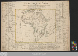
http://dx.doi.org/10.25673/60539| Title: | General Charte Von Afrika : welche Die Haupt Landschaften Enthælt, Woraus Dieser Welttheil Bestehet, Und Ihre Eintheilung In Staaten Und Provinzen, Nebst Sowohl Merckwürdigen Als Nuzbaren Anmerckungen / vom Hr. Brion Koeniglichen Ingenieur und Geographen |
| Other: | Müller, Johann Carl Johann Carl Müllers Buch- und Kunsthandlung |
| Published: | Leipzig : in Johann Carl Müllers Buch und Kunsthandlung, [circa 1790] |
| Scale: | Circa 1:23 100 000 |
| Coordinates: | W 23°00'00"-E 62°00'00"/N 37°30'00"-S 35°00'00" |
| Extent: | 1 Karte; 34 x 42 cm, auf Blatt 53 x 74 cm Kupferstich |
| Annotations: | Nullmeridian: Ferro. - Maßstab in grafischer Form (Stunde) Bergzeichnung Altkarte |
| Note: | Koloriert |
| Language: | German |
| Online Edition: | Halle (Saale) : Universitäts- und Landesbibliothek Sachsen-Anhalt, 2022 |
| Original Publication: | Universitäts- und Landesbibliothek Sachsen-Anhalt, Altkt B II 2 [8] 3 |
| URN: | urn:nbn:de:gbv:3:3-1192015415-1688635572-12 |
| URI: | https://opendata.uni-halle.de//handle/1981185920/62490 http://dx.doi.org/10.25673/60539 |
| Open Access: |  Open access publication Open access publication |
| License: |  Creative Commons Attribution 4.0") (CC BY 4.0) Creative Commons Attribution 4.0 (CC BY 4.0) Creative Commons Attribution 4.0 |
| Sponsor/Funder: | Die Digitalisierung wurde durch die Deutsche Digitale Bibliothek im Rahmen des von der Beauftragten der Bundesregierung für Kultur und Medien (BKM) geförderten Programms NEUSTART KULTUR ermöglicht. |
| Appears in Collections: | Karten und Atlanten |
Ressources:
 |
|