Bitte benutzen Sie diese Kennung, um auf die Ressource zu verweisen:
http://dx.doi.org/10.25673/61961Langanzeige der Metadaten
| DC Element | Wert | Sprache |
|---|---|---|
| dc.date.accessioned | 2022-02-01T07:22:05Z | - |
| dc.date.available | 2022-02-01T07:22:05Z | - |
| dc.date.issued | 1917 | - |
| dc.identifier.uri | https://opendata.uni-halle.de//handle/1981185920/63912 | - |
| dc.identifier.uri | http://dx.doi.org/10.25673/61961 | - |
| dc.description.sponsorship | Die Digitalisierung wurde durch die Deutsche Digitale Bibliothek im Rahmen des von der Beauftragten der Bundesregierung für Kultur und Medien (BKM) geförderten Programms NEUSTART KULTUR ermöglicht. | - |
| dc.format.extent | 1 Karte; 79 x 56 cm | - |
| dc.language.iso | ger | - |
| dc.publisher | [Königlich Preußische Landesaufnahme, Kartografische Abteilung] | - |
| dc.rights.uri | https://creativecommons.org/licenses/by/4.0/ | - |
| dc.subject | Bagdad | - |
| dc.subject.ddc | 090 | - |
| dc.subject.other | BK:74.21 | - |
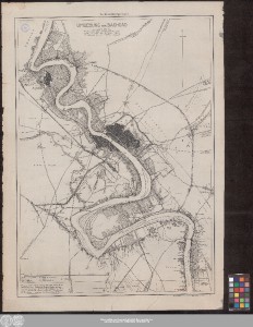
| dc.title | Umgebung von Baghdâd : aufgenommen 1916 / Photoalgraphie der Kart. Abtlg. der Kgl. Preuß. Landesaufnahme ; Routen von Hauptmann Andrae, Leutnant Preusser und Leutnant Lücke ; Triangulation von Hauptm. Becker | - |
| dc.type | Map | - |
| dc.identifier.urn | urn:nbn:de:gbv:3:3-1192015415-601232437-14 | - |
| dc.identifier.shelfmark | 05 SC 26 (Karte) | - |
| local.openaccess | true | - |
| dc.identifier.ppn | 601232437 | - |
| local.mets.uri | https://opendata.uni-halle.de/retrieve/caa08400-d394-4a98-ab1f-879b7889ed24/mets.xml | - |
| local.holding | Universitäts- und Landesbibliothek Sachsen-Anhalt | - |
| local.holding.displayform | Universitäts- und Landesbibliothek Sachsen-Anhalt, 05 SC 26 (Karte) | - |
| dc.contributor.cartographer | Andrae, Walter | - |
| dc.contributor.cartographer | Preusser, Conrad | - |
| dc.contributor.cartographer | Lücke, Fritz | - |
| dc.contributor.publisher | Königlich Preußische Landesaufnahme | - |
| dc.date.digitization | 2022 | - |
| dc.description.note | Ohne Kartennetz und Randgraduierung | - |
| dc.description.note | Mit Nordpfeil | - |
| dc.description.note | Karte | - |
| cbs.contenttype.code | cri | - |
| cbs.contenttype.text | kartografisches Bild | - |
| cbs.digitization.displayform | Halle (Saale) : Universitäts- und Landesbibliothek Sachsen-Anhalt, 2022 | - |
| cbs.publication.displayform | [Berlin] : [Königlich Preußische Landesaufnahme, Kartografische Abteilung], 1917 | - |
| cbs.picatype | Aa | - |
| local.map.scale | 1:25 000 | - |
| local.map.scale_sort | 1:25000 | - |
| dc.contributor.contributor | Becker | - |
| Enthalten in den Sammlungen: | Karten und Atlanten | |
Ressourcen:
 |
|