Please use this identifier to cite or link to this item:
http://dx.doi.org/10.25673/62471Full metadata record
| DC Field | Value | Language |
|---|---|---|
| dc.contributor.other | J. & C. Walker | - |
| dc.date.accessioned | 2022-02-03T06:53:22Z | - |
| dc.date.available | 2022-02-03T06:53:22Z | - |
| dc.date.issued | 1855 | - |
| dc.identifier.uri | https://opendata.uni-halle.de//handle/1981185920/64422 | - |
| dc.identifier.uri | http://dx.doi.org/10.25673/62471 | - |
| dc.description.sponsorship | Die Digitalisierung wurde durch die Deutsche Digitale Bibliothek im Rahmen des von der Beauftragten der Bundesregierung für Kultur und Medien (BKM) geförderten Programms NEUSTART KULTUR ermöglicht. | - |
| dc.language.iso | eng | - |
| dc.publisher | published by John Walker, geographer to the Honble. East India Company | - |
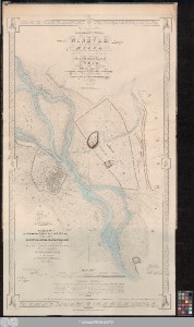
| dc.relation.haspart | Being a map of the country included in the angle formed by the river Tigris & the upper Zab : shewing the disposition of the various ancient sites in the vicinity of Nineveh | - |
| dc.relation.haspart | Shewing the positions and plan of the ancient cities of Nimrūd and Selamīyeh : the former identical with the Larissa of Xenophon perhaps the Calab of Genesis and the ... of the cuneiform inscriftions | - |
| dc.relation.haspart | An ichnographic sketch of the remains of ancient Nineveh, with the enceinte of the modern Mosul, the Moṣūl of Arab M.S.S. and the Mespila of the Anabasis | - |
| dc.rights.uri | https://creativecommons.org/licenses/by/4.0/ | - |
| dc.subject.ddc | 090 | - |
| dc.title | Vestiges of Assuria / constructed from trigonometrical survey in the spring of 1852 at the command of the government of India by Felix Jones Commander, Indian Navy & Surveyor in Mesopotamia aided in the field operations by J.M. Hyslop Esqr. M.D. Medl. Staff, Bombay Army ; engraved by J. & C. Walker | - |
| dc.type | Map | - |
| dc.identifier.urn | urn:nbn:de:gbv:3:3-1192015415-068402104-15 | - |
| local.openaccess | true | - |
| dc.identifier.ppn | 068402104 | - |
| local.mets.uri | https://opendata.uni-halle.de/retrieve/3c2ce7f1-76d1-4414-9f48-ff5905afc63a/mets.xml | - |
| dc.contributor.cartographer | Jones, James Felix | - |
| dc.contributor.publisher | Walker, John | - |
| dc.date.digitization | 2022 | - |
| dc.description.note | Maßstab in grafischer Form (feet, English statute miles, Geographical miles) | - |
| dc.description.note | Mit Nordpfeil | - |
| dc.description.note | Ohne Randgraduierung | - |
| dc.description.note | Mit Bergstrichen | - |
| dc.description.note | "True copy of the original Felix Jones. fecit et del. Baghdad 15th July 1852." | - |
| dc.description.note | Karte | - |
| cbs.contenttype.code | cri | - |
| cbs.contenttype.text | kartografisches Bild | - |
| cbs.digitization.displayform | Halle (Saale) : Universitäts- und Landesbibliothek Sachsen-Anhalt, 2022 | - |
| cbs.publication.displayform | [London] : published by John Walker, geographer to the Honble. East India Company, Feby. 2nd. 1855 | - |
| cbs.picatype | Ac | - |
| Appears in Collections: | Karten und Atlanten | |
Ressources:
 |
|