Please use this identifier to cite or link to this item:
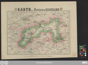
http://dx.doi.org/10.25673/85246| Title: | Karte des Kreises Aschersleben / auf Veranlassung der Königlichen Regierung, bearbeitet und herausgegeben von F. v. Rappard, Major z.D. |
| Editor: | Rappard, F., von |
| Published: | [Berlin] : [Kartographisches Institut von F. v. Rappard], [circa 1865] |
| Scale: | Circa 1:100 000 |
| Extent: | 1 Karte; 36 x 53 cm Lithografie |
| Annotations: | Maßstab in grafischer Form (Ruthen, Schritt, Meile) Kopftitel mit 2 Wappen von Aschersleben und Quedlinburg Mit wirtschaftlichen Angaben Karte |
| Note: | Koloriert |
| Language: | German |
| Subjects: | Landkreis Aschersleben |
| Online Edition: | Halle (Saale) : Universitäts- und Landesbibliothek Sachsen-Anhalt, 2022 |
| Original Publication: | Universitäts- und Landesbibliothek Sachsen-Anhalt, Altkt D II 6 [1] 15 |
| URN: | urn:nbn:de:gbv:3:3-1192015415-24131190X-17 |
| URI: | https://opendata.uni-halle.de//handle/1981185920/87198 http://dx.doi.org/10.25673/85246 |
| Open Access: |  Open access publication Open access publication |
| License: |  Creative Commons Attribution 4.0") (CC BY 4.0) Creative Commons Attribution 4.0 (CC BY 4.0) Creative Commons Attribution 4.0 |
| Appears in Collections: | Karten und Atlanten |
Ressources:
 |
|