Please use this identifier to cite or link to this item:
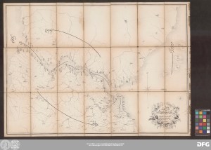
http://dx.doi.org/10.25673/85385| Title: | İstanbul ve Boğaziçi haritasıdır / Gravé par Eugène Olivier |
| Other: | Olivier, Eugène |
| Published: | [Istanbul] : [Maṭbaʿat Ǧarīdat al-Ḥawādiṯ] ; Istanbul, 1266h = 1850 |
| Publication place: | Istanbul |
| Scale: | Maßstab nicht angegeben |
| Coordinates: | E 28°49'30"-E 29°15'45"/N 41°17'15"-N 40°49'40" |
| Extent: | 1 Karte; 51 x 71 cm Lithografie |
| Annotations: | E oben Ohne Kartennetz und Randgraduierung Mit Windrose Titelkartusche unten rechts Karte von Istanbul und dem Bosporus Altkarte |
| Language: | Turkish, Ottoman Arabic French |
| Online Edition: | Halle (Saale) : Universitäts- und Landesbibliothek Sachsen-Anhalt, 2022 |
| Original Publication: | Universitäts- und Landesbibliothek Sachsen-Anhalt, Altkt B II 7 [17] 5 |
| URN: | urn:nbn:de:gbv:3:3-1192015415-178613067X-15 |
| URI: | https://opendata.uni-halle.de//handle/1981185920/87337 http://dx.doi.org/10.25673/85385 |
| Open Access: |  Open access publication Open access publication |
| License: |  Creative Commons Attribution 4.0") (CC BY 4.0) Creative Commons Attribution 4.0 (CC BY 4.0) Creative Commons Attribution 4.0 |
| Appears in Collections: | Karten und Atlanten |
Ressources:
 |
|