Please use this identifier to cite or link to this item:
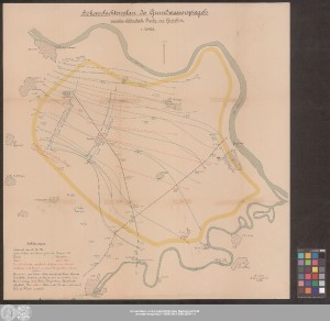
http://dx.doi.org/10.25673/38851| Title: | Höhenschichtenplan des Grundwasserspiegels zwischen Schönebeck, Barby und Grizehne / A. Thiem Kgl. Baurat u. Civilingenieur Leipzig |
| Published: | [Erscheinungsort nicht ermittelbar] : [Verlag nicht ermittelbar], [nicht vor 1898] |
| Scale: | 1:25 000 |
| Extent: | 1 Karte; 63 x 62 cm Farblithografie |
| Annotations: | Kopftitel Mit Nordpfeil Ohne Geländedarstellung Ohne Kartennetz und Randgraduierung Karte |
| Language: | German |
| Subjects: | Schönebeck (Elbe) Barby (Elbe) Landkreis Calbe (Saale) Hydrogeologische Kartierung |
| Online Edition: | Halle (Saale) : Universitäts- und Landesbibliothek Sachsen-Anhalt, 2021 |
| Original Publication: | Universitäts- und Landesbibliothek Sachsen-Anhalt, Altkt D I 5 [2] 38 |
| URN: | urn:nbn:de:gbv:3:3-1192015415-309122694-11 |
| URI: | https://opendata.uni-halle.de//handle/1981185920/39098 http://dx.doi.org/10.25673/38851 |
| Open Access: |  Open access publication Open access publication |
| License: |  Creative Commons Attribution 4.0") (CC BY 4.0) Creative Commons Attribution 4.0 (CC BY 4.0) Creative Commons Attribution 4.0 |
| Sponsor/Funder: | Die Digitalisierung wurde durch die Deutsche Digitale Bibliothek im Rahmen des von der Beauftragten der Bundesregierung für Kultur und Medien (BKM) geförderten Programms NEUSTART KULTUR ermöglicht. |
| Appears in Collections: | Karten und Atlanten |
Ressources:
 |
|