Please use this identifier to cite or link to this item:
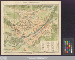
http://dx.doi.org/10.25673/38863| Title: | Übersichts-Plan der Stadt Quedlinburg / herausgegeben vom Städt. Verkehrsamt ; Kartogr. u. Druck v. Louis Koch, Halberstadt |
| Publisher / Printer: | Koch, Louis Louis Koch |
| Other: | Quedlinburg |
| Published: | [Halberstadt] : [Louis Koch], [circa 1920] |
| Scale: | 1:7 500 |
| Coordinates: | E 11°09'00"/N 51°47'18" |
| Extent: | 1 Karte; 35 x 39 cm Farblithografie |
| Annotations: | Kopftitel Mit Bergstrichen und Nordpfeil Mit Suchnetz Stadtplan |
| Language: | German |
| Subjects: | Quedlinburg Stadtplan |
| Online Edition: | Halle (Saale) : Universitäts- und Landesbibliothek Sachsen-Anhalt, 2021 |
| Original Publication: | Universitäts- und Landesbibliothek Sachsen-Anhalt, Altkt A III 2 [14] 9 |
| URN: | urn:nbn:de:gbv:3:3-1192015415-240645170-13 |
| URI: | https://opendata.uni-halle.de//handle/1981185920/39110 http://dx.doi.org/10.25673/38863 |
| Open Access: |  Open access publication Open access publication |
| License: |  Creative Commons Attribution 4.0") (CC BY 4.0) Creative Commons Attribution 4.0 (CC BY 4.0) Creative Commons Attribution 4.0 |
| Sponsor/Funder: | Die Digitalisierung wurde durch die Deutsche Digitale Bibliothek im Rahmen des von der Beauftragten der Bundesregierung für Kultur und Medien (BKM) geförderten Programms NEUSTART KULTUR ermöglicht. |
| Appears in Collections: | Karten und Atlanten |
Ressources:
 |
|