Please use this identifier to cite or link to this item:
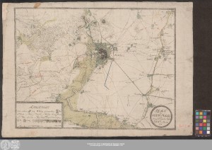
http://dx.doi.org/10.25673/38999| Title: | Plan der Stadt Halle nebst der um ihr liegenden Gegend / von P: A: W: von Hincke |
| Published: | [Halle (Saale)] : [Verlag nicht ermittelbar], 1808 |
| Scale: | Circa 1:20 000 |
| Coordinates: | E 11°51'20"-E 12°04'00"/N 51°31'25"-N 51°25'20" |
| Extent: | 1 Karte; 48 x 64 cm Kupferstich |
| Annotations: | Maßstab in grafischer Form (Schritte) Titelkartusche unten rechts. - Erklärungs- und Maßstabskartusche unten links. - Zeichner und Stecher unten links unter Kartenrahmen Ohne Kartennetz und Randgraduierung Mit Bergstrichen Auch erschienen in: Hincke, Phillipp A. W. von: Beschreibung der Affaire bei Halle, zwischen den Franzosen und einem preußischen Reserve-Corps, den 17ten Oktober 1806. - [Halle (Saale)], 1808 Altkarte Stadtplan |
| Note: | Koloriert |
| Language: | German |
| Subjects: | Halle (Saale) Stadtplan Halle (Saale) Militärkarte |
| Online Edition: | Halle (Saale) : Universitäts- und Landesbibliothek Sachsen-Anhalt, 2021 |
| Original Publication: | Universitäts- und Landesbibliothek Sachsen-Anhalt, Altkt A III 2 [13] 12 |
| URN: | urn:nbn:de:gbv:3:3-1192015415-240609077-18 |
| URI: | https://opendata.uni-halle.de//handle/1981185920/39246 http://dx.doi.org/10.25673/38999 |
| Open Access: |  Open access publication Open access publication |
| License: |  Creative Commons Attribution 4.0") (CC BY 4.0) Creative Commons Attribution 4.0 (CC BY 4.0) Creative Commons Attribution 4.0 |
| Sponsor/Funder: | Die Digitalisierung wurde durch die Deutsche Digitale Bibliothek im Rahmen des von der Beauftragten der Bundesregierung für Kultur und Medien (BKM) geförderten Programms NEUSTART KULTUR ermöglicht. |
| Appears in Collections: | Karten und Atlanten |
Ressources:
 |
|