Please use this identifier to cite or link to this item:
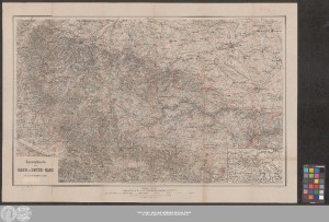
http://dx.doi.org/10.25673/39002| Title: | Specialkarte vom Ober- u. Unter-Harz / red. von Dr. Henry Lange ; Geogr. lith. Inst. u. Steindr. v. W. Greve, Kgl. Hoflith. |
| Other: | Greve, Wilhelm Wilh. Greve |
| Published: | Berlin S.W. : Verlag von Max Pasch, [1887] |
| Scale: | 1:100 000 |
| Coordinates: | E 10°09'50"-E 11°15'20"/N 51°58'00"-N 51°33'10" |
| Extent: | 1 Karte; 46 x 75 cm Farblithografie |
| Annotations: | Titelkartusche unten links Ohne Kartennetz und Randgraduierung Mit 1 Nebenkarte: "Übersichts-Karte" Mit Schummerung Karte |
| Language: | German |
| Subjects: | Harz |
| Online Edition: | Halle (Saale) : Universitäts- und Landesbibliothek Sachsen-Anhalt, 2021 |
| Original Publication: | Universitäts- und Landesbibliothek Sachsen-Anhalt, Altkt A IV 2 [7] 28 |
| URN: | urn:nbn:de:gbv:3:3-1192015415-250821079-13 |
| URI: | https://opendata.uni-halle.de//handle/1981185920/39249 http://dx.doi.org/10.25673/39002 |
| Open Access: |  Open access publication Open access publication |
| License: |  Creative Commons Attribution 4.0") (CC BY 4.0) Creative Commons Attribution 4.0 (CC BY 4.0) Creative Commons Attribution 4.0 |
| Sponsor/Funder: | Die Digitalisierung wurde durch die Deutsche Digitale Bibliothek im Rahmen des von der Beauftragten der Bundesregierung für Kultur und Medien (BKM) geförderten Programms NEUSTART KULTUR ermöglicht. |
| Appears in Collections: | Karten und Atlanten |
Ressources:
 |
|