Please use this identifier to cite or link to this item:
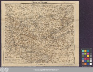
http://dx.doi.org/10.25673/39030| Title: | Karte von Thüringen |
| Published: | Berlin / Berlin : Verlag v. Albert Goldschmidt ; Geograph. lith. Anst. v. C. Korbgeweit, [um 1900] |
| Scale: | 1:300 000 |
| Coordinates: | E 10°11'15"-E 11°52'00"/N 51°09'30"-N 50°15'00" |
| Extent: | 1 Karte; 34 x 40 cm Farblithografie |
| Annotations: | Nicht identisch mit K10plus-PPN 403628415; dort: Schnellpressendruck Kopftitel Bergstriche Karte |
| Language: | German |
| Online Edition: | Halle (Saale) : Universitäts- und Landesbibliothek Sachsen-Anhalt, 2021 |
| Original Publication: | Universitäts- und Landesbibliothek Sachsen-Anhalt, 21 C 85 |
| URN: | urn:nbn:de:gbv:3:3-1192015415-1751355012-12 |
| URI: | https://opendata.uni-halle.de//handle/1981185920/39277 http://dx.doi.org/10.25673/39030 |
| Open Access: |  Open access publication Open access publication |
| License: |  Creative Commons Attribution 4.0") (CC BY 4.0) Creative Commons Attribution 4.0 (CC BY 4.0) Creative Commons Attribution 4.0 |
| Sponsor/Funder: | Die Digitalisierung wurde durch die Deutsche Digitale Bibliothek im Rahmen des von der Beauftragten der Bundesregierung für Kultur und Medien (BKM) geförderten Programms NEUSTART KULTUR ermöglicht. |
| Appears in Collections: | Karten und Atlanten |
Ressources:
 |
|