Please use this identifier to cite or link to this item:
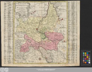
http://dx.doi.org/10.25673/39080| Title: | Ducatus Magdeburgensis Et Halensis cum finitimis Delineatio geographica / curante Matthæo Seuttero Geographo Cæsar Aug. Vindel ; Tob. Conr. Lotter sc. Aug. Vind. |
| Publisher / Printer: | Lotter, Tobias Conrad Lotter |
| Published: | In Augsburg : Anjezo im Verlag beÿ Tobias Conrad Lotter Geogr:, [zwischen 1757 und 1777] |
| Scale: | Circa 1:310 000 |
| Extent: | 1 Karte; 48 x 41 cm Kupferstich |
| Annotations: | Mit Windrose und Bergzeichnung Maßstab in grafischer Form (Teutsche Meilen) Titelkartusche oben links. - Erklärungs- und Maßstabskartusche unten links. - Verlegerkartusche unten Mitte links Mit Ortsregister rechts und links auf dem Kartenrand "Cum Priv. S. Reg. Polon. et Elect. Saxon." Altkarte Erscheinungsjahr nach Wirkungszeit des Verlegers |
| Note: | Koloriert |
| Language: | Latin |
| Subjects: | Magdeburg Halle (Saale) |
| Online Edition: | Halle (Saale) : Universitäts- und Landesbibliothek Sachsen-Anhalt, 2021 |
| Original Publication: | Universitäts- und Landesbibliothek Sachsen-Anhalt, Altkt D II 6 [1] 7 |
| URN: | urn:nbn:de:gbv:3:3-1192015415-240561511-10 |
| URI: | https://opendata.uni-halle.de//handle/1981185920/39327 http://dx.doi.org/10.25673/39080 |
| Open Access: |  Open access publication Open access publication |
| License: |  Creative Commons Attribution 4.0") (CC BY 4.0) Creative Commons Attribution 4.0 (CC BY 4.0) Creative Commons Attribution 4.0 |
| Sponsor/Funder: | Die Digitalisierung wurde durch die Deutsche Digitale Bibliothek im Rahmen des von der Beauftragten der Bundesregierung für Kultur und Medien (BKM) geförderten Programms NEUSTART KULTUR ermöglicht. |
| Appears in Collections: | Karten und Atlanten |
Ressources:
 |
|