Please use this identifier to cite or link to this item:
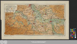
http://dx.doi.org/10.25673/39130| Title: | Physikalisch-politische Karte des Freistaates Anhalt / Kartographische Anstalt von F.A. Brockhaus, Leipzig |
| Publisher / Printer: | Hofbuchdruckerei C. Dünnhaupt |
| Published: | Dessau : Verlag der Hofbuchdruckerei C. Dünnhaupt, [circa 1905] |
| Scale: | 1:200 000 |
| Extent: | 1 Karte; 30 x 59 cm Farblithografie |
| Annotations: | Titel-, Maßstabs- und Erklärungskartusche oben links Mit Randüberzeichnung Karte |
| Language: | German |
| Subjects: | Anhalt |
| Online Edition: | Halle (Saale) : Universitäts- und Landesbibliothek Sachsen-Anhalt, 2021 |
| Original Publication: | Universitäts- und Landesbibliothek Sachsen-Anhalt, Altkt D II 6 [5] 19 |
| URN: | urn:nbn:de:gbv:3:3-1192015415-251106888-18 |
| URI: | https://opendata.uni-halle.de//handle/1981185920/39777 http://dx.doi.org/10.25673/39130 |
| Open Access: |  Open access publication Open access publication |
| License: |  Creative Commons Attribution 4.0") (CC BY 4.0) Creative Commons Attribution 4.0 (CC BY 4.0) Creative Commons Attribution 4.0 |
| Sponsor/Funder: | Die Digitalisierung wurde durch die Deutsche Digitale Bibliothek im Rahmen des von der Beauftragten der Bundesregierung für Kultur und Medien (BKM) geförderten Programms NEUSTART KULTUR ermöglicht. |
| Appears in Collections: | Karten und Atlanten |
Ressources:
 |
|