Please use this identifier to cite or link to this item:
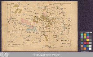
http://dx.doi.org/10.25673/39136| Title: | Situationsplan der Salzmünder-Güter |
| Publisher / Printer: | Wiegandt & Hempel Lithographische Anstalt von Leopold Kraatz |
| Published: | In Berlin / In Berlin : Verlag v. Wiegandt & Hempel ; Lith. Anst. v. Leopold Kraatz, [circa 1870] |
| Scale: | Circa 1:100 000 |
| Coordinates: | E 11°31'30"-E 12°00'50"/N 51°36'30"-N 51°22'50" |
| Extent: | 1 Karte; 23 x 34 cm Farblithografie |
| Annotations: | Maßstab in grafischer Form (Meile) Titel unten rechts. - Zeichenerklärung und Maßstab unten links Mit Randüberzeichnung Ohne Kartennetz und Randgraduierung Karte |
| Language: | German |
| Subjects: | Landwirtschaft Salzmünde |
| Online Edition: | Halle (Saale) : Universitäts- und Landesbibliothek Sachsen-Anhalt, 2021 |
| Original Publication: | Universitäts- und Landesbibliothek Sachsen-Anhalt, Altkt D II 6 [2] 2 |
| URN: | urn:nbn:de:gbv:3:3-1192015415-237001446-15 |
| URI: | https://opendata.uni-halle.de//handle/1981185920/40083 http://dx.doi.org/10.25673/39136 |
| Open Access: |  Open access publication Open access publication |
| License: |  Creative Commons Attribution 4.0") (CC BY 4.0) Creative Commons Attribution 4.0 (CC BY 4.0) Creative Commons Attribution 4.0 |
| Sponsor/Funder: | Die Digitalisierung wurde durch die Deutsche Digitale Bibliothek im Rahmen des von der Beauftragten der Bundesregierung für Kultur und Medien (BKM) geförderten Programms NEUSTART KULTUR ermöglicht. |
| Appears in Collections: | Karten und Atlanten |
Ressources:
 |
|