Please use this identifier to cite or link to this item:
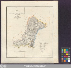
http://dx.doi.org/10.25673/39149| Title: | Karte des Wollmirstaedter-Kreises Regbz: Magdeburg / von F.A. v. Witzleben Hauptmann im Generalstabe ; Nowack gez. ; H. Delius lith. |
| Other: | Delius, Hermann |
| Published: | Berlin : [Verlag nicht ermittelbar], 1834 |
| Scale: | 1:200 000 |
| Extent: | 1 Karte; 33 x 30 cm Lithografie |
| Annotations: | Nullmeridian: Ferro. - Maßstab in grafischer Form (Meilen) Titel oben links. - Maßstab unten links Mit Bergstrichen Altkarte |
| Language: | German |
| Subjects: | Landkreis Wolmirstedt |
| Online Edition: | Halle (Saale) : Universitäts- und Landesbibliothek Sachsen-Anhalt, 2021 |
| Original Publication: | Universitäts- und Landesbibliothek Sachsen-Anhalt, Altkt A IV 5 [2] 7 |
| URN: | urn:nbn:de:gbv:3:3-1192015415-240362640-19 |
| URI: | https://opendata.uni-halle.de//handle/1981185920/40096 http://dx.doi.org/10.25673/39149 |
| Open Access: |  Open access publication Open access publication |
| License: |  Creative Commons Attribution 4.0") (CC BY 4.0) Creative Commons Attribution 4.0 (CC BY 4.0) Creative Commons Attribution 4.0 |
| Sponsor/Funder: | Die Digitalisierung wurde durch die Deutsche Digitale Bibliothek im Rahmen des von der Beauftragten der Bundesregierung für Kultur und Medien (BKM) geförderten Programms NEUSTART KULTUR ermöglicht. |
| Appears in Collections: | Karten und Atlanten |
Ressources:
 |
|