Please use this identifier to cite or link to this item:
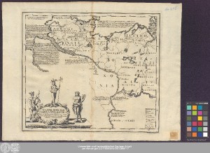
http://dx.doi.org/10.25673/39162| Title: | Sclaviæ Borealis Tabula Geographica : nova ad illustrandam Historiam medii ævi a Sæculo VIII. usq[ue] ad Sæculum XII. / auctore Matthia Johanne Beehr ; Brühl sc. Lips. |
| Publisher / Printer: | Martini, Johann Christian |
| Other: | Brühl, Johann Benjamin |
| Published: | [Leipzig] : [Johann Christian Martini], [1741] |
| Scale: | Circa 1:1 300 000 |
| Extent: | 1 Karte; 31 x 36 cm Kupferstich |
| Annotations: | Titelkartusche mit 3 Figuren unten links. - Erklärungskartusche unten rechts Mit Erläuterungen auf dem Kartenfeld Erschienen in: Behr, Matthias Johann von: Rerum Mecleburgicarum libri octo. - Leipzig : Johann Christian Martini, 1741 Ohne Kartennetz Altkarte |
| Language: | Latin |
| Subjects: | Norddeutschland Geschichtskarte Geschichte 700-1300 |
| Online Edition: | Halle (Saale) : Universitäts- und Landesbibliothek Sachsen-Anhalt, 2021 |
| Original Publication: | Universitäts- und Landesbibliothek Sachsen-Anhalt, Altkt E III 4 [4] 6 |
| URN: | urn:nbn:de:gbv:3:3-1192015415-242126987-17 |
| URI: | https://opendata.uni-halle.de//handle/1981185920/40109 http://dx.doi.org/10.25673/39162 |
| Open Access: |  Open access publication Open access publication |
| License: |  Creative Commons Attribution 4.0") (CC BY 4.0) Creative Commons Attribution 4.0 (CC BY 4.0) Creative Commons Attribution 4.0 |
| Sponsor/Funder: | Die Digitalisierung wurde durch die Deutsche Digitale Bibliothek im Rahmen des von der Beauftragten der Bundesregierung für Kultur und Medien (BKM) geförderten Programms NEUSTART KULTUR ermöglicht. |
| Appears in Collections: | Karten und Atlanten |
Ressources:
 |
|