Please use this identifier to cite or link to this item:
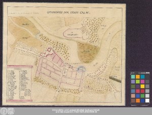
http://dx.doi.org/10.25673/39175| Title: | Grundriss der Stadt Calbe |
| Published: | [19. Jahrhundert?] |
| Scale: | Circa 1:5 000 |
| Extent: | 1 Karte; 27 x 37 cm Handzeichnung (koloriert) |
| Annotations: | Maßstab in grafischer Form (Rl. Ruthen) Ohne Kartennetz und Randgraduierung Kopftitel. - Erläuterungskartusche links unten Stadtplan Zeichnung |
| Language: | German |
| Subjects: | Calbe (Saale) Stadtplan Handgezeichnete Karte |
| Online Edition: | Halle (Saale) : Universitäts- und Landesbibliothek Sachsen-Anhalt, 2021 |
| Original Publication: | Universitäts- und Landesbibliothek Sachsen-Anhalt, Altkt E V 1 [3] 5 |
| URN: | urn:nbn:de:gbv:3:3-1192015415-254005969-18 |
| URI: | https://opendata.uni-halle.de//handle/1981185920/40122 http://dx.doi.org/10.25673/39175 |
| Open Access: |  Open access publication Open access publication |
| License: |  Creative Commons Attribution 4.0") (CC BY 4.0) Creative Commons Attribution 4.0 (CC BY 4.0) Creative Commons Attribution 4.0 |
| Sponsor/Funder: | Die Digitalisierung wurde durch die Deutsche Digitale Bibliothek im Rahmen des von der Beauftragten der Bundesregierung für Kultur und Medien (BKM) geförderten Programms NEUSTART KULTUR ermöglicht. |
| Appears in Collections: | Karten und Atlanten |
Ressources:
 |
|