Please use this identifier to cite or link to this item:
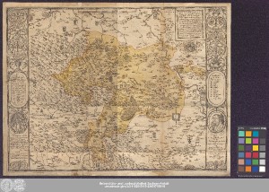
http://dx.doi.org/10.25673/39186| Title: | Mansfeldici Comitatus typus chorographicus : diligenter omnia loca perlustrantis in charta delineatus : nunc uero in gratiam et honorem Nobilium ac Generosoru[m] Comitu[m] & D. Domini Iohan[n]is Georgij, Domini Petri Ernesti, Domini Christophori, Domini Volrati, Domini Iohannis Alberti, Domini Iohannis Hoieri, Domini Iohannis Ernesti, Domini Caroli, & Domini Brunonis, Comitu[m] & Dominorum in Mansfeld, & Nobiliu[m] Dominorum in Heldru[n]gen &c: / olim manu prestantissimi artificis D.M. Tilemanni Stelle S. |
| Editor: | Mellinger, Johann |
| Dedicatee: | Mansfeld, Hans Georg, von Mansfeld-Vorderort, Peter Ernst, von Christoph <Mansfeld-Schrapelau, Graf> Mansfeld, Vollrad, von Mansfeld, Hans Albrecht, von Mansfeld, Hans Hoyer, von Johann Ernst <Mansfeld-Heldrungen, Graf> Mansfeld, Carl, zu Mansfeld, Bruno, von |
| Published: | [Jena] : in lucem editus à M. Iohanne Mellingero Halensi, Anno MD LXXI |
| Scale: | Circa 1:180 000 |
| Extent: | 1 Karte; 34 x 38 cm, auf Blatt 37 x 49 cm Kupferstich |
| Annotations: | Maßstab in grafischer Form (Gemeine Tevtsche Meilen) Ohne Kartennetz und Randgraduierung Titelkartusche mit Wappen oben rechts. - Maßstab oben Mitte. - Erklärungskartusche ("Vnterscheidt der örter") im Kartenrahmen rechts Mitte Mit 1 Papstkarrikatur und 3 Schmähtexten links im Kartenrahmen Mit 1 Porträt Martin Luthers und 2 Würdigungen rechts im Kartenrahmen Zahlreiche Wappen und einzelne historische Angaben im Kartenfeld Mit Windrose Altkarte Erscheinungsort ermittelt nach Wirkungsort Mellingers im Jahre 1571 |
| Note: | Koloriert |
| Language: | Latin |
| Subjects: | Grafschaft Mansfeld |
| Online Edition: | Halle (Saale) : Universitäts- und Landesbibliothek Sachsen-Anhalt, 2021 |
| Original Publication: | Universitäts- und Landesbibliothek Sachsen-Anhalt, Altkt D II 7 [1] 1 |
| URN: | urn:nbn:de:gbv:3:3-1192015415-236517198-19 |
| URI: | https://opendata.uni-halle.de//handle/1981185920/41140 http://dx.doi.org/10.25673/39186 |
| Open Access: |  Open access publication Open access publication |
| License: |  Creative Commons Attribution 4.0") (CC BY 4.0) Creative Commons Attribution 4.0 (CC BY 4.0) Creative Commons Attribution 4.0 |
| Sponsor/Funder: | Die Digitalisierung wurde durch die Deutsche Digitale Bibliothek im Rahmen des von der Beauftragten der Bundesregierung für Kultur und Medien (BKM) geförderten Programms NEUSTART KULTUR ermöglicht. |
| Appears in Collections: | Karten und Atlanten |
Ressources:
 |
|