Please use this identifier to cite or link to this item:
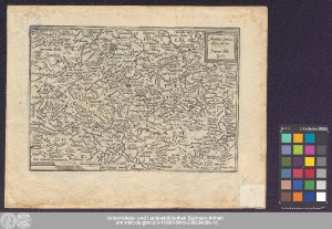
http://dx.doi.org/10.25673/39188| Title: | Mansfeldiae Comitatus descriptio / Auctore Tilemanno Stella Sig. ; henricus Nagel fecit |
| Publisher / Printer: | Bussemacher, Johann Johann Bussemacher |
| Other: | Nagel, Heinrich Quad, Matthias |
| Published: | [Köln] : [Johann Bussemacher], [1592] |
| Scale: | Circa 1:240 000 |
| Extent: | 1 Karte; 18 x 26 cm Kupferstich |
| Annotations: | Maßstab in grafischer Form (milliaria Germanica) Titelkartusche oben rechts. - Maßstab unten links. - Stechername rechts neben Maßstab Mit Bergzeichnung Ohne Kartennetz und Randgraduierung Erschienen in: Quad, Matthias: Europae totius orbis terrarum partis praestantissimae ... - Köln : Bussemacher, 1592 und öfter Altkarte Erscheinungsjahr nach Erstausgabe des Atlas |
| Language: | Latin |
| Subjects: | Grafschaft Mansfeld |
| Online Edition: | Halle (Saale) : Universitäts- und Landesbibliothek Sachsen-Anhalt, 2021 |
| Original Publication: | Universitäts- und Landesbibliothek Sachsen-Anhalt, Altkt E IV 4 [5] 1 |
| URN: | urn:nbn:de:gbv:3:3-1192015415-236634356-12 |
| URI: | https://opendata.uni-halle.de//handle/1981185920/41142 http://dx.doi.org/10.25673/39188 |
| Open Access: |  Open access publication Open access publication |
| License: |  Creative Commons Attribution 4.0") (CC BY 4.0) Creative Commons Attribution 4.0 (CC BY 4.0) Creative Commons Attribution 4.0 |
| Sponsor/Funder: | Die Digitalisierung wurde durch die Deutsche Digitale Bibliothek im Rahmen des von der Beauftragten der Bundesregierung für Kultur und Medien (BKM) geförderten Programms NEUSTART KULTUR ermöglicht. |
| Appears in Collections: | Karten und Atlanten |
Ressources:
 |
|