Please use this identifier to cite or link to this item:
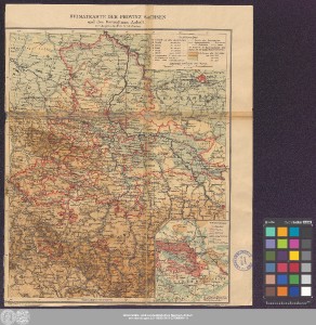
http://dx.doi.org/10.25673/39190| Title: | Heimatkarte der Provinz Sachsen und des Herzogtums Anhalt : zu Velhagen & Klasings Schulatlanten |
| Other Titles: | [Politische Karte] [Physische Karte] |
| Publisher / Printer: | Velhagen & Klasing Geographische Anstalt Velhagen & Klasing |
| Published: | In Bielefeld u. Leipzig / In Leipzig : Verlag von Velhagen & Klasing ; Geograph. Anstalt von Velhagen & Klasing, [nach 1900] |
| Scale: | 1:1 000 000 |
| Coordinates: | E 9°53'00"-E 13°46'30"/N 53°01'00"-N 50°05'00" |
| Extent: | 2 Karten auf 1 Blatt; je 34 x 28 cm, auf Blatt 38 x 31 cm beidseitig, Farblithografie |
| Annotations: | Kopftitel.- Erklärungs- und Maßstabskartusche jeweils oben rechts Mit je einer Nebenkarte unten rechts: "Bodenbenutzung" bzw. "Industrien" Mit Bergstrichen Karte |
| Language: | German |
| Subjects: | Provinz Sachsen Anhalt |
| Online Edition: | Halle (Saale) : Universitäts- und Landesbibliothek Sachsen-Anhalt, 2021 |
| Original Publication: | Universitäts- und Landesbibliothek Sachsen-Anhalt, Altkt D II 6 [2] 4 |
| URN: | urn:nbn:de:gbv:3:3-1192015415-237004844-11 |
| URI: | https://opendata.uni-halle.de//handle/1981185920/41144 http://dx.doi.org/10.25673/39190 |
| Open Access: |  Open access publication Open access publication |
| License: |  Creative Commons Attribution 4.0") (CC BY 4.0) Creative Commons Attribution 4.0 (CC BY 4.0) Creative Commons Attribution 4.0 |
| Sponsor/Funder: | Die Digitalisierung wurde durch die Deutsche Digitale Bibliothek im Rahmen des von der Beauftragten der Bundesregierung für Kultur und Medien (BKM) geförderten Programms NEUSTART KULTUR ermöglicht. |
| Appears in Collections: | Karten und Atlanten |
Ressources:
 |
|