Please use this identifier to cite or link to this item:
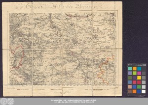
http://dx.doi.org/10.25673/39197| Title: | Gegend um Halle und Merseburg / gezeichnet von Heinrich Berghaus ; gestochen von Heinrich Brose |
| Publisher / Printer: | Hampe Commissions- und Landkarten-Handlung von E. W. Starck |
| Other: | Brose, Karl Heinrich |
| Published: | Berlin / [Berlin] : im Verlage bei E.W. Starck ; gedruckt von Hampe, 1820 |
| Scale: | Circa 1:200 000 |
| Extent: | 1 Karte; 23 x 33 cm Kupferstich |
| Annotations: | Maßstab in grafischer Form (geogr. Meile) Kopftitel Mit Bergstrichen Altkarte |
| Note: | Leinenkarte; koloriert |
| Language: | German |
| Subjects: | Halle (Saale) Merseburg |
| Online Edition: | Halle (Saale) : Universitäts- und Landesbibliothek Sachsen-Anhalt, 2021 |
| Original Publication: | Universitäts- und Landesbibliothek Sachsen-Anhalt, Altkt D II 7 [3] 2 |
| URN: | urn:nbn:de:gbv:3:3-1192015415-240192346-19 |
| URI: | https://opendata.uni-halle.de//handle/1981185920/41151 http://dx.doi.org/10.25673/39197 |
| Open Access: |  Open access publication Open access publication |
| License: |  Creative Commons Attribution 4.0") (CC BY 4.0) Creative Commons Attribution 4.0 (CC BY 4.0) Creative Commons Attribution 4.0 |
| Sponsor/Funder: | Die Digitalisierung wurde durch die Deutsche Digitale Bibliothek im Rahmen des von der Beauftragten der Bundesregierung für Kultur und Medien (BKM) geförderten Programms NEUSTART KULTUR ermöglicht. |
| Appears in Collections: | Karten und Atlanten |
Ressources:
 |
|