Please use this identifier to cite or link to this item:
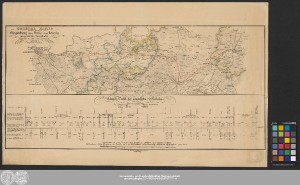
http://dx.doi.org/10.25673/39340| Title: | General Karte von der zwischen Magdeburg über Halle nach Leipzig projectirten Eisenbahn / Entworfen im Jahre 1835 u. 1836 durch Grüsou Ingenieur-Capitain |
| Other: | Pohlmann, Carl Lithographisches Institut von C. Pohlmann |
| Published: | In Magdeburg : In Stein gest. im lithgr. Institut v. C. Pohlmann, [circa 1836] |
| Scale: | 1:200 000 |
| Extent: | 1 Karte; 17 x 64 cm, auf Blatt 40 x 65 cm Lithografie |
| Annotations: | ENE oben Inselkarte Mit Bergstrichen Mit 1 Profil: "Längen-Profil der projectirten Eisenbahn" Altkarte |
| Note: | Koloriert |
| Language: | German |
| Subjects: | Leipzig Eisenbahnlinie Magdeburg Verkehr |
| Online Edition: | Halle (Saale) : Universitäts- und Landesbibliothek Sachsen-Anhalt, 2021 |
| Original Publication: | Universitäts- und Landesbibliothek Sachsen-Anhalt, Altkt D I 4 [10] 3 |
| URN: | urn:nbn:de:gbv:3:3-1192015415-265787777-14 |
| URI: | https://opendata.uni-halle.de//handle/1981185920/41296 http://dx.doi.org/10.25673/39340 |
| Open Access: |  Open access publication Open access publication |
| License: |  Creative Commons Attribution 4.0") (CC BY 4.0) Creative Commons Attribution 4.0 (CC BY 4.0) Creative Commons Attribution 4.0 |
| Sponsor/Funder: | Die Digitalisierung wurde durch die Deutsche Digitale Bibliothek im Rahmen des von der Beauftragten der Bundesregierung für Kultur und Medien (BKM) geförderten Programms NEUSTART KULTUR ermöglicht. |
| Appears in Collections: | Karten und Atlanten |
Ressources:
 |
|