Please use this identifier to cite or link to this item:
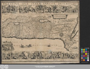
http://dx.doi.org/10.25673/39352| Title: | Palestina, Siue Terræ Sanctæ Descriptio |
| Publisher / Printer: | Jansson, Jan |
| Published: | Amstelodami : excudebat Joannes Joansonius ; Amsterdam, [circa 1636] |
| Publication place: | Amsterdam |
| Scale: | Circa 1:1 160 000 |
| Extent: | 1 Karte; 26 x 56 cm, auf Blatt 45 x 57 cm Kupferstich |
| Annotations: | Maßstab in grafischer Form (Milliaria Horæ) Ohne Kartennetz und Randgraduierung Mit Bergzeichnung Mit 1 Ansicht von Jerusalem unten links Oben 9 und unten 10 bildliche Vorstellungen aus der biblischen Geschichte mit Text Altkarte |
| Language: | Latin |
| Online Edition: | Halle (Saale) : Universitäts- und Landesbibliothek Sachsen-Anhalt, 2021 |
| Original Publication: | Universitäts- und Landesbibliothek Sachsen-Anhalt, Altkt B II 6 [3] 6 |
| URN: | urn:nbn:de:gbv:3:3-1192015415-1436377323-11 |
| URI: | https://opendata.uni-halle.de//handle/1981185920/41308 http://dx.doi.org/10.25673/39352 |
| Open Access: |  Open access publication Open access publication |
| License: |  Creative Commons Attribution 4.0") (CC BY 4.0) Creative Commons Attribution 4.0 (CC BY 4.0) Creative Commons Attribution 4.0 |
| Sponsor/Funder: | Die Digitalisierung wurde durch die Deutsche Digitale Bibliothek im Rahmen des von der Beauftragten der Bundesregierung für Kultur und Medien (BKM) geförderten Programms NEUSTART KULTUR ermöglicht. |
| Appears in Collections: | Karten und Atlanten |
Ressources:
 |
|