Please use this identifier to cite or link to this item:
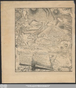
http://dx.doi.org/10.25673/39359| Title: | Plan de l'Affaire pres de Maxen le 20. et 21 Novbr. 1759 / C.G. Nestler sculps: |
| Publisher / Printer: | Barthel, Samuel Friedrich |
| Other: | Nestler, Carl Gottfried |
| Published: | [Freiberg] : [Barthel], [1777] |
| Scale: | Circa 1:22 000 |
| Coordinates: | E 13°38'20"-E 13°56'15"/N 50°58'20"-N 50°51'50" |
| Extent: | 1 Karte auf 2 Blättern; 39 x 78 cm, Blätter 50 x 45 und 45 x 59 cm Kupferstich |
| Annotations: | NW oben. - Maßstab in grafischer Form (Pas, Mile d'Allemagne) Mit Windrose und Bergstrichen Titel- und Erklärungskartusche unten links. - Maßstabskartusche mit Angabe des Stechers unten rechts Ohne Kartennetz und Randgraduierung Erschienen in: Tielke, Johann Gottlieb: Mémoires pour servir à l'art et l'histoire de la guerre de 1756 jusqu'à 1763. - Freiberg : Barthel, 1777 ; 1re partie, Pl. II Altkarte |
| Language: | French |
| Subjects: | Maxen Militärkarte |
| Online Edition: | Halle (Saale) : Universitäts- und Landesbibliothek Sachsen-Anhalt, 2021 |
| Original Publication: | Universitäts- und Landesbibliothek Sachsen-Anhalt, Altkt C II 6 [1] 2-3 |
| URN: | urn:nbn:de:gbv:3:3-1192015415-248789554-15 |
| URI: | https://opendata.uni-halle.de//handle/1981185920/41315 http://dx.doi.org/10.25673/39359 |
| Open Access: |  Open access publication Open access publication |
| License: |  Creative Commons Attribution 4.0") (CC BY 4.0) Creative Commons Attribution 4.0 (CC BY 4.0) Creative Commons Attribution 4.0 |
| Sponsor/Funder: | Die Digitalisierung wurde durch die Deutsche Digitale Bibliothek im Rahmen des von der Beauftragten der Bundesregierung für Kultur und Medien (BKM) geförderten Programms NEUSTART KULTUR ermöglicht. |
| Appears in Collections: | Karten und Atlanten |
Ressources:
 |
|