Please use this identifier to cite or link to this item:
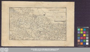
http://dx.doi.org/10.25673/39409| Title: | Position de toutes les Armees et Corps en Saxe le 19e et 20. Novbr: 1759 / C.G. Werner Sculps. |
| Publisher / Printer: | Barthel, Samuel Friedrich |
| Other: | Werner, Christian Gottlieb |
| Published: | [Freiberg] : [Barthel], [1777] |
| Scale: | Circa 1:170 000 |
| Coordinates: | E 13°20'00"-E 14°03'00"/N 51°10'30"-N 50°49'30" |
| Extent: | 1 Karte; 17 x 30 cm Kupferstich |
| Annotations: | NNE oben. - Maßstab in grafischer Form (Mille) Mit Nordpfeil und Bergstrichen Titel-, Erklärungs- und Maßstabskartusche oben rechts. - Stecher unten rechts unter Kartenrahmen Erschienen in: Tielke, Johann Gottlieb: Mémoires pour servir à l'art et l'histoire de la guerre de 1756 jusqu'à 1763. - Freiberg : Barthel, 1777 ; 1re partie, Pl. I Ohne Kartennetz und Randgraduierung Altkarte |
| Note: | Koloriert |
| Language: | French |
| Subjects: | Dresden Militärkarte |
| Online Edition: | Halle (Saale) : Universitäts- und Landesbibliothek Sachsen-Anhalt, 2021 |
| Original Publication: | Universitäts- und Landesbibliothek Sachsen-Anhalt, Altkt C II 6 [1] 1 |
| URN: | urn:nbn:de:gbv:3:3-1192015415-248788264-13 |
| URI: | https://opendata.uni-halle.de//handle/1981185920/41365 http://dx.doi.org/10.25673/39409 |
| Open Access: |  Open access publication Open access publication |
| License: |  Creative Commons Attribution 4.0") (CC BY 4.0) Creative Commons Attribution 4.0 (CC BY 4.0) Creative Commons Attribution 4.0 |
| Sponsor/Funder: | Die Digitalisierung wurde durch die Deutsche Digitale Bibliothek im Rahmen des von der Beauftragten der Bundesregierung für Kultur und Medien (BKM) geförderten Programms NEUSTART KULTUR ermöglicht. |
| Appears in Collections: | Karten und Atlanten |
Ressources:
 |
|