Bitte benutzen Sie diese Kennung, um auf die Ressource zu verweisen:
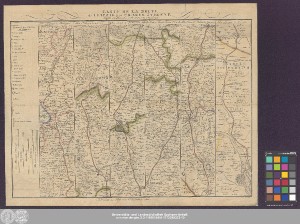
http://dx.doi.org/10.25673/39430| Titel: | Carte De La Route de Leipzic par Prague à Vienne : dressée en Bandes à la maniere Angloise / gez. von Reineke |
| VerlegerIn / DruckerIn: | Landes-Industrie-Comptoir zu Weimar |
| Erschienen: | À Weimar : au Bureau d'Industrie, 1802 |
| Maßstab: | Circa 1:260 000 |
| Umfang: | 1 Karte in 6 Teilen; 34 x 42 cm, auf Blatt 40 x 50 cm Kupferstich |
| Anmerkungen: | Maßstab in grafischer Form (Mille géogr. d'Allemagne, Mille de Bohême, Mille de Moravie ...) Kopftitel Ohne Kartennetz und Randgraduierung Mit Bergstrichen Streifenkarte mit 6 Einzelstrecken mit je eigenem Titel Altkarte |
| Hinweis: | Koloriert |
| Sprache: | Französisch |
| Schlagwörter: | Straßenkarte Leipzig |
| Online-Ausgabe: | Halle (Saale) : Universitäts- und Landesbibliothek Sachsen-Anhalt, 2021 |
| Vorlage der Digitalisierung: | Universitäts- und Landesbibliothek Sachsen-Anhalt, Altkt D I 4 [10] 2 |
| URN: | urn:nbn:de:gbv:3:3-1192015415-1772285323-10 |
| URI: | https://opendata.uni-halle.de//handle/1981185920/41386 http://dx.doi.org/10.25673/39430 |
| Open-Access: |  Open-Access-Publikation Open-Access-Publikation |
| Nutzungslizenz: |  Creative Commons Namensnennung 4.0 International") (CC BY 4.0) Creative Commons Namensnennung 4.0 International (CC BY 4.0) Creative Commons Namensnennung 4.0 International |
| Sponsor/Geldgeber: | Die Digitalisierung wurde durch die Deutsche Digitale Bibliothek im Rahmen des von der Beauftragten der Bundesregierung für Kultur und Medien (BKM) geförderten Programms NEUSTART KULTUR ermöglicht. |
| Enthalten in den Sammlungen: | Karten und Atlanten |
Ressourcen:
 |
|