Please use this identifier to cite or link to this item:
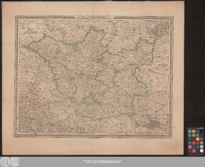
http://dx.doi.org/10.25673/45208| Title: | Preussische Provinz Brandenburg / Gez. v. C.F. Weiland, berichtigt 1846 v. H. Kiepert |
| Published: | Weimar : Geographisches Institut, 1849 |
| Scale: | Circa 1:630 000 |
| Coordinates: | E 11°04'-E 16°37'/N 53°42'-N 51°09' |
| Extent: | 1 Karte; 44 x 58 cm Stich |
| Annotations: | Nullmeridian: Ferro. - Maßstab in grafischer Form (Geograph. Meilen, Preussische Meilen) Kopftitel. - Erklärungen und Maßstab oben links Mit 2 Nebenkarten: "Die nächste Umgebung von Potsdam", "Die nächste Umgebung von Berlin" Altkarte |
| Note: | Koloriert |
| Language: | German |
| Subjects: | Brandenburg |
| Online Edition: | Halle (Saale) : Universitäts- und Landesbibliothek Sachsen-Anhalt, 2021 |
| Original Publication: | Universitäts- und Landesbibliothek Sachsen-Anhalt, Altkt D II 4 [2] 1 |
| URN: | urn:nbn:de:gbv:3:3-1192015415-240412389-14 |
| URI: | https://opendata.uni-halle.de//handle/1981185920/47159 http://dx.doi.org/10.25673/45208 |
| Open Access: |  Open access publication Open access publication |
| License: |  Creative Commons Attribution 4.0") (CC BY 4.0) Creative Commons Attribution 4.0 (CC BY 4.0) Creative Commons Attribution 4.0 |
| Sponsor/Funder: | Die Digitalisierung wurde durch die Deutsche Digitale Bibliothek im Rahmen des von der Beauftragten der Bundesregierung für Kultur und Medien (BKM) geförderten Programms NEUSTART KULTUR ermöglicht. |
| Appears in Collections: | Karten und Atlanten |
Ressources:
 |
|