Bitte benutzen Sie diese Kennung, um auf die Ressource zu verweisen:
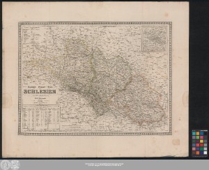
http://dx.doi.org/10.25673/56574| Titel: | Koenigl: Preuss: Prov: Schlesien / entworfen und gezeichnet von C.F. Weiland |
| VerlegerIn / DruckerIn: | Geographisches Institut zu Weimar |
| Erschienen: | Weimar : Im Verlage des Geographischen Instit., 1848 |
| Maßstab: | Circa 1:730 000 |
| Koordinaten: | E 13°28'-E 19°20'/N 52°22'-N 49°42' |
| Umfang: | 1 Karte; 41 x 57 cm Lithografie |
| Anmerkungen: | Nullmeridian: Ferro. - Maßstab in grafischer Form (Geographische Meilen, Preussische Meilen) Titel links Mitte unten. - Maßstab unten Mitte links. - Erklärungen oben links. - Tabelle mit statistischer Übersicht links unten Mit 1 Nebenkarte: "Die nächste Umgebung von Breslau" Mit Aufzählung von Bergspitzen im Riesengebirge Mit Bergstrichen Altkarte |
| Hinweis: | Koloriert |
| Sprache: | Deutsch |
| Schlagwörter: | Schlesien |
| Online-Ausgabe: | Halle (Saale) : Universitäts- und Landesbibliothek Sachsen-Anhalt, 2022 |
| Vorlage der Digitalisierung: | Universitäts- und Landesbibliothek Sachsen-Anhalt, Altkt D III 5 [2] 3 |
| URN: | urn:nbn:de:gbv:3:3-1192015415-311158196-14 |
| URI: | https://opendata.uni-halle.de//handle/1981185920/58526 http://dx.doi.org/10.25673/56574 |
| Open-Access: |  Open-Access-Publikation Open-Access-Publikation |
| Nutzungslizenz: |  Creative Commons Namensnennung 4.0 International") (CC BY 4.0) Creative Commons Namensnennung 4.0 International (CC BY 4.0) Creative Commons Namensnennung 4.0 International |
| Sponsor/Geldgeber: | Die Digitalisierung wurde durch die Deutsche Digitale Bibliothek im Rahmen des von der Beauftragten der Bundesregierung für Kultur und Medien (BKM) geförderten Programms NEUSTART KULTUR ermöglicht. |
| Enthalten in den Sammlungen: | Karten und Atlanten |
Ressourcen:
 |
|