Please use this identifier to cite or link to this item:
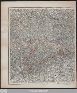
http://dx.doi.org/10.25673/56576| Title: | Karte von Schlesien, Sachsen, Nord Böhmen / entworfen von F.B. Engelhardt |
| Publisher / Printer: | Simon Schropp und Comp. in Berlin |
| Other: | Königliches Lithographisches Institut |
| Published: | Berlin / [Berlin] : Verlag der Simon Schropp'schen Hof-Landkartenhandlung (L. Beringuier.) ; Berliner lith. Institut, [circa 1860] |
| Scale: | 1:600 000 |
| Coordinates: | E 10°50'-E 19°40'/N 52°50'-N 49°30' |
| Extent: | 1 Karte auf 2 Blättern; 58 x 107 cm, Blätter 69 x 61 cm Lithografie |
| Annotations: | Nullmeridian: Ferro Titel, Maßstab und Verleger rechts oben Mit Randüberzeichnung Karte |
| Note: | Koloriert |
| Language: | German |
| Subjects: | Sachsen Schlesien Nordböhmisches Gebiet |
| Online Edition: | Halle (Saale) : Universitäts- und Landesbibliothek Sachsen-Anhalt, 2022 |
| Original Publication: | Universitäts- und Landesbibliothek Sachsen-Anhalt, Altkt D III 5 [3] 3-4 |
| URN: | urn:nbn:de:gbv:3:3-1192015415-311747914-19 |
| URI: | https://opendata.uni-halle.de//handle/1981185920/58528 http://dx.doi.org/10.25673/56576 |
| Open Access: |  Open access publication Open access publication |
| License: |  Creative Commons Attribution 4.0") (CC BY 4.0) Creative Commons Attribution 4.0 (CC BY 4.0) Creative Commons Attribution 4.0 |
| Sponsor/Funder: | Die Digitalisierung wurde durch die Deutsche Digitale Bibliothek im Rahmen des von der Beauftragten der Bundesregierung für Kultur und Medien (BKM) geförderten Programms NEUSTART KULTUR ermöglicht. |
| Appears in Collections: | Karten und Atlanten |
Ressources:
 |
|