Please use this identifier to cite or link to this item:
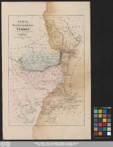
http://dx.doi.org/10.25673/58087| Title: | Karte des Kriegsschauplatzes in der Türkey / entworfen und gezeichnet von T. Koenig |
| Publisher / Printer: | Carl Barthol |
| Published: | Berlin : Verlag von Carl Barthol, 1853 |
| Scale: | Circa 1:2 900 000 |
| Coordinates: | E 20°20'00"-E 31°00'00"/N 48°15'00"-N 39°00'00" |
| Extent: | 1 Karte; 36 x 25 cm Lithografie |
| Annotations: | Bergstriche Karte |
| Language: | German |
| Online Edition: | Halle (Saale) : Universitäts- und Landesbibliothek Sachsen-Anhalt, 2022 |
| Original Publication: | Universitäts- und Landesbibliothek Sachsen-Anhalt, Altkt B II 7 [8] 1 |
| URN: | urn:nbn:de:gbv:3:3-1192015415-1725118041-17 |
| URI: | https://opendata.uni-halle.de//handle/1981185920/60038 http://dx.doi.org/10.25673/58087 |
| Open Access: |  Open access publication Open access publication |
| License: |  Creative Commons Attribution 4.0") (CC BY 4.0) Creative Commons Attribution 4.0 (CC BY 4.0) Creative Commons Attribution 4.0 |
| Sponsor/Funder: | Die Digitalisierung wurde durch die Deutsche Digitale Bibliothek im Rahmen des von der Beauftragten der Bundesregierung für Kultur und Medien (BKM) geförderten Programms NEUSTART KULTUR ermöglicht. |
| Appears in Collections: | Karten und Atlanten |
Ressources:
 |
|