Bitte benutzen Sie diese Kennung, um auf die Ressource zu verweisen:
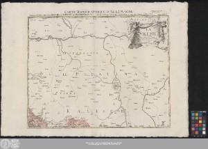
http://dx.doi.org/10.25673/59620| Titel: | Carte Topographique D'Allemagne Contenant une petite anglet de la Silesie et les Confins du Grand Pologne / fait par I.W. Iaeger ; [Titelkartusche:] Gravé par Berndt |
| Teil: | Feuille XXVII |
| Beteiligt: | Berndt, Johann Christoph |
| Erschienen: | À Francfort sur le Mein : se vend chèz l'Auteur ; Frankfurt am Main, [1789] |
| Erscheinungsort: | Frankfurt am Main |
| Maßstab: | Circa 1:220 000 |
| Umfang: | 1 Karte; 45 x 58 cm Kupferstich |
| Anmerkungen: | Maßstab in grafischer Form (Lieues d'Allemagne) "A.P. de S.M.I." Mit Bergstrichen Kopftitel. - Titelkartusche für das Kartenwerk als Extraplatte oben rechts. - Maßstab oben rechts auf dem Kartenrand Altkarte |
| Hinweis: | Koloriert |
| Sprache: | Französisch |
| Online-Ausgabe: | Halle (Saale) : Universitäts- und Landesbibliothek Sachsen-Anhalt, 2022 |
| Vorlage der Digitalisierung: | Universitäts- und Landesbibliothek Sachsen-Anhalt, Altkt D II 2 [1] 2 |
| URN: | urn:nbn:de:gbv:3:3-1192015415-242477763-14 |
| URI: | https://opendata.uni-halle.de//handle/1981185920/61571 http://dx.doi.org/10.25673/59620 |
| Open-Access: |  Open-Access-Publikation Open-Access-Publikation |
| Nutzungslizenz: |  Creative Commons Namensnennung 4.0 International") (CC BY 4.0) Creative Commons Namensnennung 4.0 International (CC BY 4.0) Creative Commons Namensnennung 4.0 International |
| Sponsor/Geldgeber: | Die Digitalisierung wurde durch die Deutsche Digitale Bibliothek im Rahmen des von der Beauftragten der Bundesregierung für Kultur und Medien (BKM) geförderten Programms NEUSTART KULTUR ermöglicht. |
| Enthalten in den Sammlungen: | Karten und Atlanten |
Ressourcen:
 |
|