Please use this identifier to cite or link to this item:
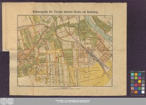
http://dx.doi.org/10.25673/60521| Title: | Bebauungsplan des Terrains zwischen Buckau und Sudenburg / O. v. Bomsdorff, geographische Anstalt, Leipzig |
| Publisher / Printer: | Albert Rathke |
| Other: | Bomsdorff, Otto, von |
| Published: | Magdeburg : Verlag von Albert Rathke's Buch- und Landkartenhandlung, [1891?] |
| Scale: | 1:8 000 |
| Extent: | 1 Karte; 30 x 40 cm, gefaltet 21 x 14 cm Farblithografie |
| Annotations: | NNE oben Ohne Kartennetz und Randgraduierung Kopftitel Mit Nordpfeil Stadtplan |
| Language: | German |
| Online Edition: | Halle (Saale) : Universitäts- und Landesbibliothek Sachsen-Anhalt, 2022 |
| Original Publication: | Universitäts- und Landesbibliothek Sachsen-Anhalt, Pon Yd 81 |
| URN: | urn:nbn:de:gbv:3:3-1192015415-101267486X-14 |
| URI: | https://opendata.uni-halle.de//handle/1981185920/62472 http://dx.doi.org/10.25673/60521 |
| Open Access: |  Open access publication Open access publication |
| License: |  Creative Commons Attribution 4.0") (CC BY 4.0) Creative Commons Attribution 4.0 (CC BY 4.0) Creative Commons Attribution 4.0 |
| Sponsor/Funder: | Die Digitalisierung wurde durch die Deutsche Digitale Bibliothek im Rahmen des von der Beauftragten der Bundesregierung für Kultur und Medien (BKM) geförderten Programms NEUSTART KULTUR ermöglicht. |
| Appears in Collections: | Karten und Atlanten |
Ressources:
 |
|