Please use this identifier to cite or link to this item:
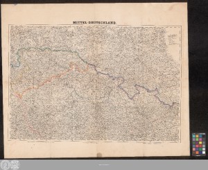
http://dx.doi.org/10.25673/60563| Title: | F. Handtke's specielle Karte von Mittel-Deutschland : (Böhmen, Mähren, Schlesien, Sachsen etc.) |
| Other Titles: | Mittel-Deutschland |
| Publisher / Printer: | Flemming |
| Published: | In Glogau : Druck u. Verlag v. C. Flemming, [circa 1870] |
| Scale: | 1:600 000 |
| Coordinates: | E 11°55'-E 18°28'/N 52°05'-N 49°11' |
| Extent: | 1 Karte; 52 x 78 cm Lithografie |
| Annotations: | Nullmeridian: Ferro Karte |
| Note: | Koloriert |
| Language: | German |
| Subjects: | Mitteldeutschland Böhmen Mähren Schlesien |
| Online Edition: | Halle (Saale) : Universitäts- und Landesbibliothek Sachsen-Anhalt, 2022 |
| Original Publication: | Universitäts- und Landesbibliothek Sachsen-Anhalt, Altkt K II 7 [1] 4 |
| URN: | urn:nbn:de:gbv:3:3-1192015415-309033675-16 |
| URI: | https://opendata.uni-halle.de//handle/1981185920/62514 http://dx.doi.org/10.25673/60563 |
| Open Access: |  Open access publication Open access publication |
| License: |  Creative Commons Attribution 4.0") (CC BY 4.0) Creative Commons Attribution 4.0 (CC BY 4.0) Creative Commons Attribution 4.0 |
| Sponsor/Funder: | Die Digitalisierung wurde durch die Deutsche Digitale Bibliothek im Rahmen des von der Beauftragten der Bundesregierung für Kultur und Medien (BKM) geförderten Programms NEUSTART KULTUR ermöglicht. |
| Appears in Collections: | Karten und Atlanten |
Ressources:
 |
|